1
The Knock River, Orangefield Park, Belfast (September 2015)
The Knock River, after completion of the flood alleviation works, with vegetation now growing along the banks, looking downstream towards here
Image (October 2013).
Image: © Albert Bridge
Taken: 10 Sep 2015
0.03 miles
2
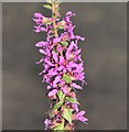
Purple loosestrife, Orangefield Park, Belfast (September 2015)
Purple loosestrife http://www.habitas.org.uk/flora/species.asp?item=3524 growing along the bank of the realigned Knock River.
Image: © Albert Bridge
Taken: 10 Sep 2015
0.04 miles
3
Stop cock cover, Orangefield Park, Belfast (September 2015)
An anonymous stop cock cover in the path near the tennis courts. It pre-dates the Connswater Greenway works. For others see http://www.geograph.org.uk/of/stop+cock+cover
Image: © Albert Bridge
Taken: 10 Sep 2015
0.06 miles
4
The Knock River, Orangefield Park, Belfast - July 2014(2)
The improved channel of the Knock River and the new flood embankment (left), looking upstream towards Clarawood.
Image: © Albert Bridge
Taken: 12 Jul 2014
0.08 miles
5
Pond, Orangefield Park, Belfast (September 2015)
A new pond, created as part of the Connswater Greenway scheme, close to the back of Clarawood House
Image
Image: © Albert Bridge
Taken: 10 Sep 2015
0.12 miles
6
New path, Clarawood, Belfast (September 2015)
A new paved path (not yet open), created as part of the Connswater Greenway scheme, running south, close to the back of Clarawood House
Image
Image: © Albert Bridge
Taken: 10 Sep 2015
0.14 miles
7
The Knock River, Belfast - May 2014(2)
The Knock River, looking upstream along the new longer and more winding course, from the bridge near Orangefield Lane. There is extensive planting underway along the banks.
Image: © Albert Bridge
Taken: 10 May 2014
0.14 miles
8
The Knock River, Belfast - May 2014(1)
The Knock River, in Orangefield Park, seen through the contractor’s safety fence. The new path is at the bottom. The banks are being planted.
Image: © Albert Bridge
Taken: 10 May 2014
0.14 miles
9
Cyprus Avenue
The inspiration for the Van Morrison song of the same name.
Image: © Paul McIlroy
Taken: 22 Oct 2005
0.14 miles
10
The diverted Knock River, Orangefield Park, Belfast (2)
The Knock River, looking upstream, on its new course through Orangefield Park. Although successfully diverted there is still quite a bit of work remaining. This view
Image in December 2011 shows the same (approximate) area long before work started on the scheme.
Image: © Albert Bridge
Taken: 1 Feb 2014
0.14 miles


