IMAGES TAKEN NEAR TO
Dunraven Avenue, BELFAST, BT5 5PH
Introduction
This page details the photographs taken nearby to Dunraven Avenue, BT5 5PH by members of the Geograph project.
The Geograph project started in 2005 with the aim of publishing, organising and preserving representative images for every square kilometre of Great Britain, Ireland and the Isle of Man.

There are currently over 7.5m images from over14,400 individuals and you can help contribute to the project by visiting https://www.geograph.org.uk
Image Map
Images are licensed for reuse under creativecommons.org/licenses/by-sa/2.0
Notes
- Clicking on the map will re-center to the selected point.
- The higher the marker number, the further away the image location is from the centre of the postcode.
Image Listing (194 Images Found)
Images are licensed for reuse under creativecommons.org/licenses/by-sa/2.0
Image
Details
Distance
1
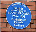
Danny Blanchflower plaque, Belfast (March 2015)
A blue plaque unveiled yesterday, at Grace Avenue Image, commemorating the footballer Danny Blanchflower. Three links – one to a biography http://www.newulsterbiography.co.uk/index.php/home/viewPerson/1785 and two to YouTube https://www.youtube.com/watch?v=EshL3T5iDUY and https://www.youtube.com/watch?v=60mKKMxaiDU. For the record he was born in nearby Dunraven Park.
Image: © Albert Bridge
Taken: 28 Mar 2015
0.02 miles
2
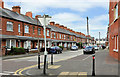
Grace Avenue, Belfast
A street of late 19th century terrace houses, off the Bloomfield Road, running from Bloomfield Gardens to Woodcot Avenue. The view is from the corner of Dunraven Avenue Image towards Woodcot Avenue. Image shows the cast name sign.
Image: © Albert Bridge
Taken: 2 Jun 2011
0.04 miles
3
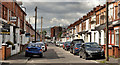
Hyndford Street, Belfast (2)
See Image (January 2010). The view in the other direction – from Dunraven Avenue Image to the Beersbridge Road and the Owen O’Cork Mill Image Construction of the street started in the very early 20th century.
Image: © Albert Bridge
Taken: 28 Apr 2012
0.04 miles
4
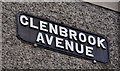
Glenbrook Avenue, Belfast (2)
The cast name sign at the Grace Avenue end of Glenbrook Avenue Image
Image: © Albert Bridge
Taken: 2 Jun 2011
0.04 miles
5
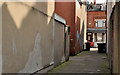
Back entry, Belfast (8)
Image: © Albert Bridge
Taken: 5 Mar 2012
0.04 miles
6
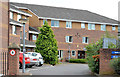
Greenville Court, Belfast
Housing association housing on the eastern side of Woodcot Avenue. Shown as Greenville Road on the Google map.
Image: © Albert Bridge
Taken: 9 Sep 2013
0.06 miles
7
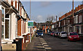
Kensington Avenue, Belfast
A street of terrace houses, built around the end of the 19th century, running from Grace Avenue Image to the Bloomfield Road Image (background). It was once suggested to me that the houses were built to for bakery workers but the street directories show that the occupants had a wide range of employment.
Image: © Albert Bridge
Taken: 5 Mar 2012
0.07 miles
8
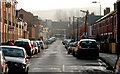
Hyndford Street, Belfast
A street, of terrace houses, off the Beersbridge Road. There has been some redevelopment on the north eastern (left) side. Better known as the childhood home of George Ivan Morrison. Image shows the view in the opposite direction in April 2012.
Image: © Albert Bridge
Taken: 25 Jan 2010
0.08 miles
9
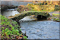
Con O'Neill's bridge, Belfast
Reputedly the oldest surviving structure in Belfast. Built on what were the lands of Con O’Neill, a 16th Irishman who owned much of east Ulster (later lost to Scottish settlers). Described (in 1967) by Charles Brett as “a hoop of ancient stonework crumbling shamefully at the foot of a pylon in the derelict wasteland behind Abetta Parade” – nothing has changed . . . . (Still in use by the way). Image (October 2012) shows the bridge, partly-submerged, after heavy overnight rain. Image shows the bridge after completion of restoration etc under the Connswater Greenway scheme.
Image: © Albert Bridge
Taken: 25 Jan 2010
0.08 miles
10
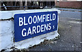
Bloomfield Gardens, Belfast (2)
An unusual blue street sign, incorporating the old postal district number, mounted at ground level at the Greenville Road end of Bloomfield Gardens Image
Image: © Albert Bridge
Taken: 16 Nov 2011
0.08 miles