IMAGES TAKEN NEAR TO
Greenville Road, BELFAST, BT5 5JY
Introduction
This page details the photographs taken nearby to Greenville Road, BT5 5JY by members of the Geograph project.
The Geograph project started in 2005 with the aim of publishing, organising and preserving representative images for every square kilometre of Great Britain, Ireland and the Isle of Man.

There are currently over 7.5m images from over14,400 individuals and you can help contribute to the project by visiting https://www.geograph.org.uk
Image Map
Images are licensed for reuse under creativecommons.org/licenses/by-sa/2.0
Notes
- Clicking on the map will re-center to the selected point.
- The higher the marker number, the further away the image location is from the centre of the postcode.
Image Listing (168 Images Found)
Images are licensed for reuse under creativecommons.org/licenses/by-sa/2.0
Image
Details
Distance
1
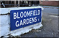
Bloomfield Gardens, Belfast (2)
An unusual blue street sign, incorporating the old postal district number, mounted at ground level at the Greenville Road end of Bloomfield Gardens Image
Image: © Albert Bridge
Taken: 16 Nov 2011
0.01 miles
2
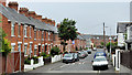
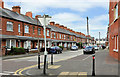
Greenville Road, Belfast
A street, developed over a period in the early 20th century, running from Grand Parade to Dunraven Avenue Image (background).
Image: © Albert Bridge
Taken: 15 Jul 2011
0.02 miles
3
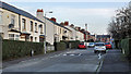
Bloomfield Gardens, Belfast (1)
A street running from the Greenville Road to the Bloomfield Road Image (background). It seems to date from after WW1 and might be one of several streets, in the immediate area, built of the site of a number of larger houses. Image shows the unusual street name sign at the Greenville Road end.
Image: © Albert Bridge
Taken: 16 Nov 2011
0.05 miles
4
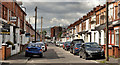
Hyndford Street, Belfast (2)
See Image (January 2010). The view in the other direction – from Dunraven Avenue Image to the Beersbridge Road and the Owen O’Cork Mill Image Construction of the street started in the very early 20th century.
Image: © Albert Bridge
Taken: 28 Apr 2012
0.06 miles
5
Grace Avenue, Belfast
A street of late 19th century terrace houses, off the Bloomfield Road, running from Bloomfield Gardens to Woodcot Avenue. The view is from the corner of Dunraven Avenue Image towards Woodcot Avenue. Image shows the cast name sign.
Image: © Albert Bridge
Taken: 2 Jun 2011
0.08 miles
6
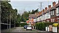
Dunraven Gardens, Belfast
A street of post-WW1 semis, off Grand Parade, overlooking Dixon Park Image (left).
Image: © Albert Bridge
Taken: 24 May 2011
0.08 miles
7
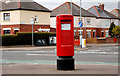
Pillar box, Belfast
EIIR pillar box, in Grand Parade, at the corner of Dunraven Park.
Image: © Albert Bridge
Taken: 28 Mar 2011
0.08 miles
8
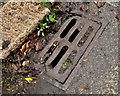
"Patent" grating cover, Belfast
A grating cover, at the Grand Parade end of Dunraven Park, bearing the word “patent” but no foundry name. Not the same as this one Image Image shows a similar (but not identical) cover at Upper Crescent.
Image: © Albert Bridge
Taken: 31 Dec 2011
0.09 miles
9
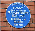
Danny Blanchflower plaque, Belfast (March 2015)
A blue plaque unveiled yesterday, at Grace Avenue Image, commemorating the footballer Danny Blanchflower. Three links – one to a biography http://www.newulsterbiography.co.uk/index.php/home/viewPerson/1785 and two to YouTube https://www.youtube.com/watch?v=EshL3T5iDUY and https://www.youtube.com/watch?v=60mKKMxaiDU. For the record he was born in nearby Dunraven Park.
Image: © Albert Bridge
Taken: 28 Mar 2015
0.09 miles
10
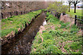
The Knock River, Belfast (2)
See Image The view upstream from this footbridge Image The Dixon Park playing fields are on the right. The area is included in the Connswater Greenway project. Continue to Image Image shows a similar view after completion of the Connswater Greenway works.
Image: © Albert Bridge
Taken: 28 Mar 2011
0.09 miles