IMAGES TAKEN NEAR TO
Bloomfield Gardens, BELFAST, BT5 5JU
Introduction
This page details the photographs taken nearby to Bloomfield Gardens, BT5 5JU by members of the Geograph project.
The Geograph project started in 2005 with the aim of publishing, organising and preserving representative images for every square kilometre of Great Britain, Ireland and the Isle of Man.

There are currently over 7.5m images from over14,400 individuals and you can help contribute to the project by visiting https://www.geograph.org.uk
Image Map
Images are licensed for reuse under creativecommons.org/licenses/by-sa/2.0
Notes
- Clicking on the map will re-center to the selected point.
- The higher the marker number, the further away the image location is from the centre of the postcode.
Image Listing (179 Images Found)
Images are licensed for reuse under creativecommons.org/licenses/by-sa/2.0
Image
Details
Distance
1
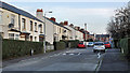
Bloomfield Gardens, Belfast (1)
A street running from the Greenville Road to the Bloomfield Road Image (background). It seems to date from after WW1 and might be one of several streets, in the immediate area, built of the site of a number of larger houses. Image shows the unusual street name sign at the Greenville Road end.
Image: © Albert Bridge
Taken: 16 Nov 2011
0.03 miles
2
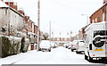
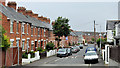
Clarendon Avenue, Belfast
A street (off the Bloomfield Road), built at the end of the 19th century, seen today just as the snow was easing.
Image: © Albert Bridge
Taken: 6 Jan 2010
0.05 miles
3
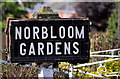
Norbloom Gardens sign, Belfast
Tiled sign, mounted on a non-standard concrete post in a garden wall, at the Grand Parade end of Norbloom Gardens.
Image: © Albert Bridge
Taken: 24 May 2011
0.06 miles
4
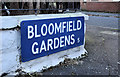
Bloomfield Gardens, Belfast (2)
An unusual blue street sign, incorporating the old postal district number, mounted at ground level at the Greenville Road end of Bloomfield Gardens Image
Image: © Albert Bridge
Taken: 16 Nov 2011
0.06 miles
5
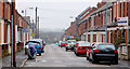
Greenville Road, Belfast
A street, developed over a period in the early 20th century, running from Grand Parade to Dunraven Avenue Image (background).
Image: © Albert Bridge
Taken: 15 Jul 2011
0.07 miles
6
Dunraven Avenue, Belfast
A street, off the Bloomfield Road, built over a period in the early 20th century.
Image: © Albert Bridge
Taken: 18 Feb 2011
0.07 miles
7
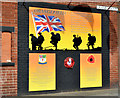
36th (Ulster) Division mural, Orangefield, Belfast
A mural, at the Bloomfield roundabout end of Grand Parade, in memory of local soldiers in the 36th (Ulster) Division, Royal Irish Rifles who served during WW1.
Image: © Albert Bridge
Taken: 9 Sep 2013
0.08 miles
8
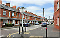
Grace Avenue, Belfast
A street of late 19th century terrace houses, off the Bloomfield Road, running from Bloomfield Gardens to Woodcot Avenue. The view is from the corner of Dunraven Avenue Image towards Woodcot Avenue. Image shows the cast name sign.
Image: © Albert Bridge
Taken: 2 Jun 2011
0.08 miles
9
Drop box, Belfast
A drop box, with a liberal coating of graffiti, at the Bloomfield Road end of Luxor Gardens Image
Image: © Albert Bridge
Taken: 5 Mar 2012
0.09 miles
10
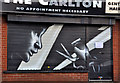
Decorated shutter door, Belfast
A recent example – this one is on a barber’s shop close to the Bloomfield roundabout Image
Image: © Albert Bridge
Taken: 16 Nov 2011
0.09 miles