IMAGES TAKEN NEAR TO
Dunraven Avenue, BELFAST, BT5 5JS
Introduction
This page details the photographs taken nearby to Dunraven Avenue, BT5 5JS by members of the Geograph project.
The Geograph project started in 2005 with the aim of publishing, organising and preserving representative images for every square kilometre of Great Britain, Ireland and the Isle of Man.

There are currently over 7.5m images from over14,400 individuals and you can help contribute to the project by visiting https://www.geograph.org.uk
Image Map
Images are licensed for reuse under creativecommons.org/licenses/by-sa/2.0
Notes
- Clicking on the map will re-center to the selected point.
- The higher the marker number, the further away the image location is from the centre of the postcode.
Image Listing (197 Images Found)
Images are licensed for reuse under creativecommons.org/licenses/by-sa/2.0
Image
Details
Distance
1
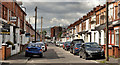
Hyndford Street, Belfast (2)
See Image (January 2010). The view in the other direction – from Dunraven Avenue Image to the Beersbridge Road and the Owen O’Cork Mill Image Construction of the street started in the very early 20th century.
Image: © Albert Bridge
Taken: 28 Apr 2012
0.02 miles
2
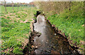
The Knock River, Belfast (3)
See Image The view downstream from this footbridge Image The Dixon Park playing fields are on the left. The area is included in the Connswater Greenway project. Continue to Image Image shows a similar view in November 2016 after completion of the Connswater Greenway works.
Image: © Albert Bridge
Taken: 28 Mar 2011
0.05 miles
3
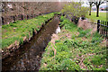
The Knock River, Belfast (2)
See Image The view upstream from this footbridge Image The Dixon Park playing fields are on the right. The area is included in the Connswater Greenway project. Continue to Image Image shows a similar view after completion of the Connswater Greenway works.
Image: © Albert Bridge
Taken: 28 Mar 2011
0.06 miles
4
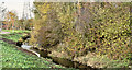
The Knock River, Belfast - November 2016(1)
The Knock River (Conn’s Water on the Google map), looking downstream from beside this footbridge Image The banks and surrounding area have been tidied and a new path built. This is a similar view Image, in March 2011, before work started.
Image: © Albert Bridge
Taken: 14 Nov 2016
0.07 miles
5
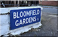
Bloomfield Gardens, Belfast (2)
An unusual blue street sign, incorporating the old postal district number, mounted at ground level at the Greenville Road end of Bloomfield Gardens Image
Image: © Albert Bridge
Taken: 16 Nov 2011
0.07 miles
6
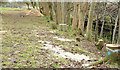
Knock River works, Belfast - February 2015(3)
The green space, between Dunraven Gardens and the northern side of the Knock River, close to this footbridge Image Trees have been cut down in preparation for the next phase of the flood alleviation work. My understanding is that they will be replaced upon completion.
Image: © Albert Bridge
Taken: 21 Feb 2015
0.07 miles
7
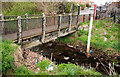
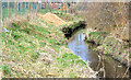
Footbridge, Belfast
A footbridge, at Dunraven Avenue Image, across the Knock River Image The depth marker is (I think) used to monitor the water level in a river prone to flooding after heavy rain. The area is included in the Connswater Greenway project. Image shows the replacement.
Image: © Albert Bridge
Taken: 28 Mar 2011
0.07 miles
8
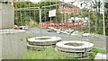
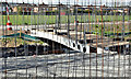
Knock River works, Belfast (August 2015)
Flood relief works underway, on this section of the Knock River (Conn’s Water on the Google map) Image, downstream from Grand Parade. For reference purposes Dunraven Avenue is in the background.
Image: © Albert Bridge
Taken: 2 Aug 2015
0.07 miles
9
New footbridge, Knock River, Belfast - April 2016(2)
See Image A second uncompleted footbridge a short distance downstream. It replaces this one Image (March 2011). There was no work underway or contractor on site today. The official website’s last comments (16 March 2016) were “In the Dixon Playing Fields area, drainage works are complete and planting has begun” and “Landscaping works continue from Abetta Parade to the Beersbridge Road area as well as in the Dixon Playing Fields.“
Image: © Albert Bridge
Taken: 25 Apr 2016
0.07 miles
10
Knock River works, Belfast - February 2015(1)
The Knock River (Conn’s Water on the Google map), looking downstream from this footbridge Image, where vegetation has been cleared from the bank in preparation for the next phase of the flood alleviation work. Image is a similar view in March 2011.
Image: © Albert Bridge
Taken: 21 Feb 2015
0.07 miles