IMAGES TAKEN NEAR TO
Factory Street, BELFAST, BT5 5AW
Introduction
This page details the photographs taken nearby to Factory Street, BT5 5AW by members of the Geograph project.
The Geograph project started in 2005 with the aim of publishing, organising and preserving representative images for every square kilometre of Great Britain, Ireland and the Isle of Man.

There are currently over 7.5m images from over14,400 individuals and you can help contribute to the project by visiting https://www.geograph.org.uk
Image Map
Images are licensed for reuse under creativecommons.org/licenses/by-sa/2.0
Notes
- Clicking on the map will re-center to the selected point.
- The higher the marker number, the further away the image location is from the centre of the postcode.
Image Listing (364 Images Found)
Images are licensed for reuse under creativecommons.org/licenses/by-sa/2.0
Image
Details
Distance
1
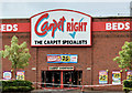
The fire-damaged "Carpet Right", Belfast (June 2014)
The Carpet Right premises, at the Arches Retail Park, were damaged by a fire during trading hours yesterday.
Image: © Albert Bridge
Taken: 8 Jun 2014
0.04 miles
2
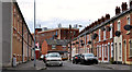
Bloomfield Street, Belfast (3)
See Image Bloomfield Street, looking in the opposite direction – from Factory Street Image The former Owen O’Cork mill Image is in the background.
Image: © Albert Bridge
Taken: 22 Aug 2011
0.04 miles
3
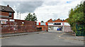
Factory Street, Belfast
A short street, once in the shadow of the Belfast Ropeworks, built in the late 19th century when it had but five houses and the factory of Ross Bros, damask manufacturers and finishers. There was also a longer Factory Street South.
Image: © Albert Bridge
Taken: 22 Aug 2011
0.04 miles
4
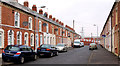
Bloomfield Street, Belfast (1)
A street, built in the early part of the 20th century, of traditional terrace houses. Now tucked away behind the Connswater Shopping Centre, it and the adjoining streets are all cul-de-sacs. With no through traffic the area is so quiet that a whistling kettle can be heard at 100 yards. See also Image
Image: © Albert Bridge
Taken: 18 Feb 2011
0.05 miles
5
Weir, Connswater, Belfast (December 2017)
The weir, at the Connswater Bridge Image, was removed during the Greenway works. This one, further upstream, between the Connswater Link and Avoniel, remains untouched.
Image: © Albert Bridge
Taken: 22 Dec 2017
0.06 miles
6
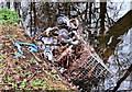
Abandoned shopping trolley, Belfast
An abandoned shopping trolley in this section of the Knock River Image
Image: © Albert Bridge
Taken: 18 Feb 2011
0.07 miles
7
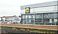
Lidl, Connswater, Belfast (December 2017)
The Lidl, beside the Connswater, at the Connswater Retail Park. It opened in July 2017 replacing a smaller one in the same development. Reportedly the biggest of the company’s stores in NI . . . . unless they expand this one Image I have no connection with the business.
Image: © Albert Bridge
Taken: 22 Dec 2017
0.07 miles
8
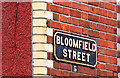
Bloomfield Street, Belfast (2)
The cast sign, with painted postal district number, at the Bloomfield Parade end (south western side) of Bloomfield Street Image Continue to Image
Image: © Albert Bridge
Taken: 18 Feb 2011
0.07 miles
9
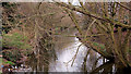
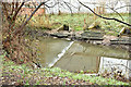
The Knock River, Belfast (10)
Part of the Knock River, downstream of Image seen from the footbridge
Image behind Bloomfield Parade. This stretch of the river is one along which the Connswater Greenway plans will be particularly welcome.
Image: © Albert Bridge
Taken: 18 Feb 2011
0.08 miles
10
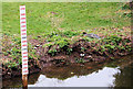
The Knock River, Belfast (11)
A depth marker in this section of the Knock River Image
Image: © Albert Bridge
Taken: 18 Feb 2011
0.08 miles