IMAGES TAKEN NEAR TO
Bloomfield Avenue, BELFAST, BT5 5AA
Introduction
This page details the photographs taken nearby to Bloomfield Avenue, BT5 5AA by members of the Geograph project.
The Geograph project started in 2005 with the aim of publishing, organising and preserving representative images for every square kilometre of Great Britain, Ireland and the Isle of Man.

There are currently over 7.5m images from over14,400 individuals and you can help contribute to the project by visiting https://www.geograph.org.uk
Image Map
Images are licensed for reuse under creativecommons.org/licenses/by-sa/2.0
Notes
- Clicking on the map will re-center to the selected point.
- The higher the marker number, the further away the image location is from the centre of the postcode.
Image Listing (552 Images Found)
Images are licensed for reuse under creativecommons.org/licenses/by-sa/2.0
Image
Details
Distance
1
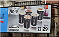
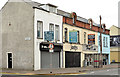
"McCaf?" poster, Belfast (March 2017)
A McDonald's McCafé advertising poster at the corner of Ashdale Street and Bloomfield Avenue.
Image: © Albert Bridge
Taken: 29 Mar 2017
0.02 miles
2
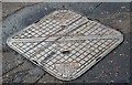
Savage SW access covers, Belfast - September 2015(1)
Savage (Nuneaton) SW (surface water) access covers at the Bloomfield Avenue end of Ashdale Street. Image shows the foundry name and date of casting.
Image: © Albert Bridge
Taken: 12 Sep 2015
0.02 miles
3
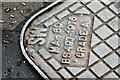
Savage SW access covers, Belfast - September 2015(2)
See Image Detail from one of the covers showing that it was cast, in 1976, to British Standard 497.
Image: © Albert Bridge
Taken: 12 Sep 2015
0.02 miles
4
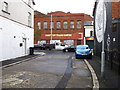
Bloomfield Avenue development site, Belfast
Formerly a garage on the north eastern side of Bloomfield Avenue – now derelict. I seem to remember that the site had planning permission for a replacement building which remains unbuilt. Laburnum Lane Image is between the site and the red gable. Image (April 2013) shows the site after demolition.
Image: © Albert Bridge
Taken: 6 Nov 2011
0.03 miles
5
Bloomfield Avenue, Belfast
The view along Bloomfield Avenue towards the Newtownards Road with the old Inglis biscuit factory (now the “Arches Centre”) at the far left. The construction of the Connswater Shopping Centre in 1983 led to a number of the properties becoming shops. It is now a mixed residential and commercial street.
Image: © Albert Bridge
Taken: 31 Oct 2007
0.03 miles
6
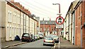
Queen Victoria Street, Belfast
A short street running from Ravenscroft Avenue Image to Bloomfield Avenue Image (background). The houses have been rendered.
Image: © Albert Bridge
Taken: 16 Jun 2009
0.03 miles
7
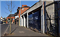
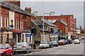
Shops, Bloomfield Avenue, Belfast
Four shops between Queen Victoria Street (left) and Bloomdale Street. Two closed and to let. One trading and to let. One trading. Official figures released today disclose “More recent figures for October 2013 show that the number of unemployment benefit claimants decreased by 600 over the month. There has been a fall of 3,900 in the claimant figures over the last 9 months.”
Image: © Albert Bridge
Taken: 13 Nov 2013
0.04 miles
8
Part of the Portview Trade Centre visible from an unnamed cul-de-sac on the Newtownards Road
Image: © Eric Jones
Taken: 3 Nov 2014
0.05 miles
9

Bloomfield Avenue development site, Belfast (2013-1)
See Image (November 2011). The derelict garage has now been demolished.
Image: © Albert Bridge
Taken: 11 Apr 2013
0.05 miles
10
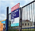
Development site, Bloomfield Avenue, Belfast - August 2015(2)
An “agreed” patch on the agents’ sign.
Image: © Albert Bridge
Taken: 4 Aug 2015
0.05 miles