IMAGES TAKEN NEAR TO
Paulett Avenue, BELFAST, BT5 4HD
Introduction
This page details the photographs taken nearby to Paulett Avenue, BT5 4HD by members of the Geograph project.
The Geograph project started in 2005 with the aim of publishing, organising and preserving representative images for every square kilometre of Great Britain, Ireland and the Isle of Man.

There are currently over 7.5m images from over14,400 individuals and you can help contribute to the project by visiting https://www.geograph.org.uk
Image Map
Images are licensed for reuse under creativecommons.org/licenses/by-sa/2.0
Notes
- Clicking on the map will re-center to the selected point.
- The higher the marker number, the further away the image location is from the centre of the postcode.
Image Listing (248 Images Found)
Images are licensed for reuse under creativecommons.org/licenses/by-sa/2.0
Image
Details
Distance
1
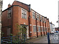
The vestry at the Ballymacarrett First Presbyterian Church
This building, now disused, was built in 1928.
Image: © Eric Jones
Taken: 3 Nov 2014
0.01 miles
2
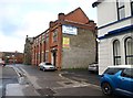
The First Presbyterian Church, Paulett Avenue, Ballymacarrett
This church built in 1837 closed its doors in 2010 when the congregation amalgamated with the Ravenhill congregation. The church, and later its brick built vestry, served a poor working class area on the interface with the Catholic Short Strand enclave.
http://www.newsletter.co.uk/news/regional/historic-church-holds-final-service-1-1849444
Image
Image: © Eric Jones
Taken: 3 Nov 2014
0.02 miles
3
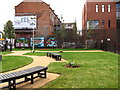
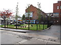
The Bridge Community Garden
This is located on a site which was previously used as a BT vehicle parking area. The land was donated for the garden project by BT and the garden was dedicated in September 2014. This image was taken from Paulett Avenue.
http://www.soundscapepark.org/?page_id=39
Image: © Eric Jones
Taken: 3 Nov 2014
0.02 miles
4
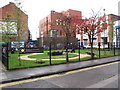
The Bridge Community Garden on Albertbridge Road
This newly opened community garden is part of the Soundscape Park Project and features a sound system which play sounds from other environments such as the sea-shore and a tropical jungle. The white building overlooking the garden contains the offices of the Business in the Community organisation.
http://www.soundscapepark.org/?page_id=53
http://www.bitcni.org.uk/news/community-organisations-welcome-new-east-belfast-green-space/
Image: © Eric Jones
Taken: 3 Nov 2014
0.02 miles
5
The Bridge Community Garden from Paulett Avenue
The car in the background is travelling along Albertbridge Road.
http://www.communityni.org/news/gates-new-east-belfast-community-garden-officially-open#.VF9YDyqsV8E
Image: © Eric Jones
Taken: 3 Nov 2014
0.02 miles
6
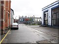
View south along Paulett Avenue towards Albertbridge Road
The offices of Business in the Community on the right is fronted by the Bridge Community Garden. On the left are the brick-built vestry of the now disused Ballymacarrett First Presbyterian Church and the local offices of the Ulster Unionist Party.
Image: © Eric Jones
Taken: 3 Nov 2014
0.02 miles
7
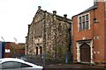
The stone built Ballymacarrett First Presbyterian Church
The church closed its doors in 2010 after 173 years of service. The red brick vestry next door was built in 1928. The two are located next to the peace wall separating them from the Catholic Short Strand area. During The Troubles, the congregation had to pass through a BA check-point to get to the church.
http://www.newsletter.co.uk/news/regional/historic-church-holds-final-service-1-1849444
Image: © Eric Jones
Taken: 3 Nov 2014
0.02 miles
8
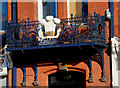
The King Building, Belfast (detail)
Balcony ironwork on the King Building (formerly the Musgrave Foundry, Mountpottinger Works) on the Albertbridge Road.
Image: © Albert Bridge
Taken: 14 Mar 2010
0.02 miles
9
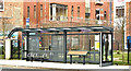
Templemore Avenue EWAY halt, Belfast - March 2018(1)
The outward Templemore Avenue halt - now used by existing Metro and Ulsterbus services.
Image: © Albert Bridge
Taken: 18 Mar 2018
0.02 miles
10
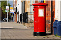
Pillar box, Belfast
EIIR pillar box on the Albertbridge Road, close to Cluan Place. The “notice” refers to a missing cat.
Image: © Albert Bridge
Taken: 3 Apr 2011
0.02 miles