IMAGES TAKEN NEAR TO
Cherry Place, COLERAINE, BT52 2AB
Introduction
This page details the photographs taken nearby to Cherry Place, BT52 2AB by members of the Geograph project.
The Geograph project started in 2005 with the aim of publishing, organising and preserving representative images for every square kilometre of Great Britain, Ireland and the Isle of Man.

There are currently over 7.5m images from over14,400 individuals and you can help contribute to the project by visiting https://www.geograph.org.uk
Image Map
Images are licensed for reuse under creativecommons.org/licenses/by-sa/2.0
Notes
- Clicking on the map will re-center to the selected point.
- The higher the marker number, the further away the image location is from the centre of the postcode.
Image Listing (44 Images Found)
Images are licensed for reuse under creativecommons.org/licenses/by-sa/2.0
Image
Details
Distance
1
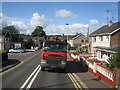
Lorry at level crossing
A lorry waiting at the level crossing at Artillery Road Coleraine. Taken from the train.
Image: © Willie Duffin
Taken: 9 Sep 2010
0.04 miles
2
Calf Lane level crossing, Coleraine (3)
See Image (June 2012). An earlier view of the crossing when it had manually-operated gates.
Image: © Albert Bridge
Taken: 16 Feb 1985
0.05 miles
3
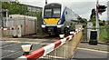
Calf Lane level crossing, Coleraine (1)
See Image (November 2006). C4K set 4008 approaching Calf Lane level crossing, on the Artillery Road, with the 13.15 Coleraine – Portrush.
Image: © Albert Bridge
Taken: 13 Jun 2012
0.05 miles
4
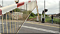
Calf Lane level crossing, Coleraine (2)
The automatic full barriers rising after the passage of the 13.15 Coleraine – Portrush Image over Calf Lane level crossing.
Image: © Albert Bridge
Taken: 13 Jun 2012
0.05 miles
5
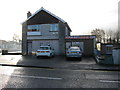
Disused travel agency Coleraine
Nutts Travel Agency and former Post Office now closed.
Image: © Willie Duffin
Taken: 8 Jan 2014
0.06 miles
6
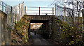
Railway underbridge, Coleraine (5)
A bridge, carrying the Coleraine (right) – Portrush line across a path leading off the Portrush Road.
Image: © Albert Bridge
Taken: 14 Nov 2011
0.07 miles
7
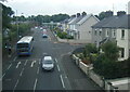
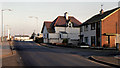
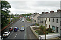
Millburn Road, Coleraine from a Derry train
Image: © Colin Pyle
Taken: 30 Jul 2022
0.07 miles
8
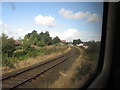
Railway track going towards Londonderry
The railway track going towards Londonderry just before it merges with the Coleraine/Portrush line.
Image: © Willie Duffin
Taken: 9 Sep 2010
0.08 miles
10
Railway underbridge, Coleraine (4)
See Image The “bridge strike” sign on the western side. 20 years ago the bridge was struck by an oversize lorry Image
Image: © Albert Bridge
Taken: 14 Nov 2011
0.11 miles