IMAGES TAKEN NEAR TO
Mountsandel Road, COLERAINE, BT52 1JE

Introduction

This page details the photographs taken nearby to Mountsandel Road, BT52 1JE by members of the Geograph project.

The Geograph project started in 2005 with the aim of publishing, organising and preserving representative images for every square kilometre of Great Britain, Ireland and the Isle of Man.

There are currently over 7.5m images from over14,400 individuals and you can help contribute to the project by visiting https://www.geograph.org.uk

Image Map


Images are licensed for reuse under creativecommons.org/licenses/by-sa/2.0
Notes
  • Clicking on the map will re-center to the selected point.
  • The higher the marker number, the further away the image location is from the centre of the postcode.

Image Listing (16 Images Found)

Images are licensed for reuse under creativecommons.org/licenses/by-sa/2.0
Image
Details
Distance
1
The Coleraine ring road (1980)
See Image (June 2006). An earlier view, looking towards the Lodge Road roundabout (far distance) on a quiet Sunday morning. The widely-separated carriageways always looked a bit unusual. They might have been intended to accommodate a future flyover – something now suggested in the Northern Area Plan 2016 Coleraine Borough: Coleraine Transportation: “Lodge Road Roundabout, located where the A26 and A29 converge at the key junction on the network. The junction is anticipated to see a significant increase in the already high flows and, should this occur, will require a significant intervention towards the end of the Plan period to maintain efficient operation. Analysis has shown that grade separation of the traffic moving through the junction on the A29 axis would provide significant benefits in terms of improving capacity and maintaining turning provision”.
Image: © Albert Bridge Taken: 29 Jun 1980
0.09 miles
2
Road near Mountsandel, Coleraine
To the right is Coleraine courthouse.
Image: © Kenneth Allen Taken: 14 Aug 2007
0.10 miles
3
Coleraine Courthouse
It is located to the south-east of the town.
Image: © Kenneth Allen Taken: 14 Aug 2007
0.10 miles
4
Flyover, Coleraine
The flyover carrying the Mountsandel Road across the ring road. The town centre is to the right.
Image: © Albert Bridge Taken: 14 Apr 2012
0.12 miles
5
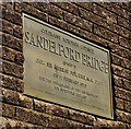
Bridge plaque, Coleraine
A plaque, on the northern side, marking the opening of the Sandelford Bridge, on 1 February 1975, by the Lord Mayor of London Sir Murray Fox.
Image: © Albert Bridge Taken: 14 Apr 2012
0.13 miles
6
Mountsandel Road Bridge, A29
Image: © N Chadwick Taken: 20 Oct 2021
0.13 miles
7
Bridge and Rainbow
Image: © Dave Green Taken: 21 Nov 2006
0.19 miles
8
The Sandelford Bridge, Coleraine
See Image The Sandelford Bridge carries the ring road across the Bann. It was the vantage point for Image The river is flowing from right to left.
Image: © Albert Bridge Taken: 18 Mar 2008
0.19 miles
9
Mountsandel Bridge, Coleraine
Looking north from the Bann
Image: © Kenneth Allen Taken: 17 Aug 2010
0.19 miles
10
Mountsandel Bridge, Coleraine.
Image: © David Laverty Taken: 8 Mar 2009
0.20 miles