IMAGES TAKEN NEAR TO
Springbank Road, COLERAINE, BT51 4SB
Introduction
This page details the photographs taken nearby to Springbank Road, BT51 4SB by members of the Geograph project.
The Geograph project started in 2005 with the aim of publishing, organising and preserving representative images for every square kilometre of Great Britain, Ireland and the Isle of Man.

There are currently over 7.5m images from over14,400 individuals and you can help contribute to the project by visiting https://www.geograph.org.uk
Image Map
Images are licensed for reuse under creativecommons.org/licenses/by-sa/2.0
Notes
- Clicking on the map will re-center to the selected point.
- The higher the marker number, the further away the image location is from the centre of the postcode.
Image Listing (10 Images Found)
Images are licensed for reuse under creativecommons.org/licenses/by-sa/2.0
Image
Details
Distance
1
Peacocks on the Burrenmore Road
Peahens to be precise. No idea where they came from!
Image: © Rossographer
Taken: 13 Oct 2007
0.07 miles
2
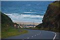
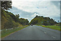
Downhill to Downhill
The A2 road from Coleraine to Limavady passes inland rising gently from Coleraine past Castlerock before falling steeply to the coast at Downhill. At Downhill it meets the Atlantic. This is the view towards Downhill Strand from near the Lion’s Gate. Note that the strand and sea are in another square.
Image: © Albert Bridge
Taken: 2 Aug 2006
0.08 miles
3
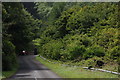
Burrenmore Road, Downhill
The Burrenmore Road is an unclassified road running from the Mussenden Road at Downhill, through Downhill Forest, in the general direction of Ballyhacket. There is no other suitable description! This is the start of the road near the Lion’s Gate to the Downhill estate.
Image: © Albert Bridge
Taken: 2 Aug 2006
0.08 miles
4
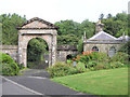
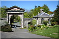
Gate house
A picturesque entrance for the former Downhill House occupied by the Bishop of Derry which was started in 1770 and destroyed by fire in 1851, and rebuilt but in 1949, it was stripped down which was a tragic shame.
Image: © Kenneth Allen
Taken: 22 Aug 2005
0.14 miles
5
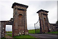
Lion Gate, Downhill Demesne, Seacoast Road, Castlerock
Built around 1780 the Lion Gate was the first to be built and then called the West Gate. The B+ listed gate was topped by two heraldic ounces, beasts similar to lynxes or leopards. By the 1970s only one ounce remained and this single remaining 18th century ounce had to be removed in 2005 for safety reasons and the gates are pictured here before the replicas by Corin Johnston were installed in October 2008. The original was taken to a specialist stone conservator in London, where it was restored and used as a model for the new ounces. Gate lodges originally stood on either side of the gateway which were probably erected in 1791. The 1831 OS map shows two lodges but by 1977 only one survived that, despite being listed in 1978, succumbed to road widening by the DoE in the early 1980s.
Image: © Jo and Steve Turner
Taken: 10 Sep 2006
0.20 miles
6
Mussenden Road
The Mussenden Road at this point is close by the walled garden of Downhill House. The temple also of the same name is not visible at this place on the road.
Image: © Malcolm Neal
Taken: 27 Jul 2022
0.21 miles
8
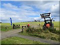
Car park entrance off Mussenden Road
Car park for a kite festival.
Image: © Richard Webb
Taken: 4 Aug 2013
0.23 miles
9
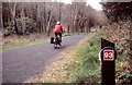
Downhill Forest
Downhill Forest is part of the National Cycle Network Route 93, a long distance route between Derry and Belfast. It is a mainly coastal on-road route from here to Belfast.
Image: © Robert Ashby
Taken: Unknown
0.23 miles
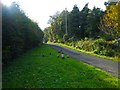
10
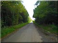
The Springbank Road, Downhill
Minor road close to Downhill Forest running south from the A2 Seacoast Road.
Image: © Rossographer
Taken: 13 Oct 2007
0.23 miles