IMAGES TAKEN NEAR TO
Garron Road, BALLYMENA, BT44 0RA
Introduction
This page details the photographs taken nearby to Garron Road, BT44 0RA by members of the Geograph project.
The Geograph project started in 2005 with the aim of publishing, organising and preserving representative images for every square kilometre of Great Britain, Ireland and the Isle of Man.

There are currently over 7.5m images from over14,400 individuals and you can help contribute to the project by visiting https://www.geograph.org.uk
Image Map
Images are licensed for reuse under creativecommons.org/licenses/by-sa/2.0
Notes
- Clicking on the map will re-center to the selected point.
- The higher the marker number, the further away the image location is from the centre of the postcode.
Image Listing (17 Images Found)
Images are licensed for reuse under creativecommons.org/licenses/by-sa/2.0
Image
Details
Distance
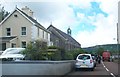
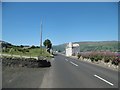
2
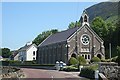
Church at Glenariff
This is the church marked on the map at the bend in the A2 by the south end of the beach.
Image: © Anne Burgess
Taken: 7 Jun 2007
0.09 miles
3
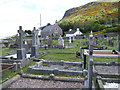
Church and cemetery at Glenariff
Image: © Jonathan Billinger
Taken: 14 May 2007
0.09 miles
5
Guests arriving for a wedding at St Patrick & St Brigid, Waterfoot
This is the Catholic Church serving the village of Glenariff/Waterfoot.
Image: © Eric Jones
Taken: 13 Aug 2011
0.10 miles
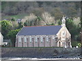
6
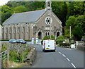
The Church of St Patrick and St Brigid
Roman Catholic Church on the Coast Road at Glenariff.
Image: © David Dixon
Taken: 28 Sep 2017
0.10 miles
7
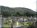
The Catholic Cemetery at Glenariff/Waterfoot
Waterfoot and Glenariff are overwhemingly Catholic communities (98%) so is the town Cushendall further north with 96.9% of its population from a Catholic background.
Image: © Eric Jones
Taken: 26 Sep 2013
0.15 miles
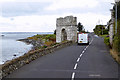
8
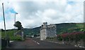
Dismantled railway bridge
The bridge carried a mineral line across the Garron Road and on to the pier. The short lived line and harbour was built in the 1879s by the Glenariff Iron Ore Mines and Harbour Co, but mining difficulties and the exposed harbour led to bankruptcy.
http://en.wikipedia.org/wiki/Glenariff_Iron_Ore_and_Harbour_Company
Image: © Eric Jones
Taken: 13 Aug 2011
0.18 miles
9
Glenariff, bridge piers
Once carrying the Glenariff Railway across Garron Road (A2), from iron ore mines at Cargan to a pier, traces of which survive in the sea.
Image: © Mike Faherty
Taken: 24 Jun 2018
0.18 miles
10
The White Arch on Carron Road
The former railway bridge was used to carry minerals across the Garron Road, onto the pier. The narrow gauge railway was operated by The Glenariff Iron Ore and Harbour Company .
Image: © David Dixon
Taken: 28 Sep 2017
0.18 miles