IMAGES TAKEN NEAR TO
Upper Newtownards Road, BELFAST, BT4 3GE
Introduction
This page details the photographs taken nearby to Upper Newtownards Road, BT4 3GE by members of the Geograph project.
The Geograph project started in 2005 with the aim of publishing, organising and preserving representative images for every square kilometre of Great Britain, Ireland and the Isle of Man.

There are currently over 7.5m images from over14,400 individuals and you can help contribute to the project by visiting https://www.geograph.org.uk
Image Map
Images are licensed for reuse under creativecommons.org/licenses/by-sa/2.0
Notes
- Clicking on the map will re-center to the selected point.
- The higher the marker number, the further away the image location is from the centre of the postcode.
Image Listing (355 Images Found)
Images are licensed for reuse under creativecommons.org/licenses/by-sa/2.0
Image
Details
Distance
1
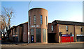
Ballyhackamore library, Belfast
The present library, at the corner of Eastleigh Drive and the Upper Newtownards Road, opened in 1992 as a joint public/private venture – library upstairs and shops on the ground floor. It replaced a “temporary” building. Now one of several in Belfast listed for closure. In the event the library did not close. See also Image
Image: © Albert Bridge
Taken: 4 Apr 2010
0.00 miles
2
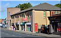
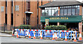
Library Court, Ballyhackamore, Belfast
The block of shops, at the corner of Eastleigh Drive and the Upper Newtownards Road (foreground), described in Image April 2010. The library is upstairs. Image shows the Eastleigh Drive side.
Image: © Albert Bridge
Taken: 9 Aug 2013
0.01 miles
3
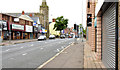
The Upper Newtownards Road (EWAY), Ballyhackamore, Belfast - June 2014(6)
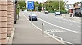
The view, inward, along the Upper Newtownards Road at Library Court Image There are no bus-priority measures or waiting restrictions here.
Image: © Albert Bridge
Taken: 8 Jun 2014
0.01 miles
4
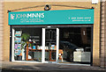
John Minnis, Ballyhackamore, Belfast
A branch of the John Minnis estate agency http://www.johnminnis.co.uk/ at Library Court Image, 404 Upper Newtownards Road.
Image: © Albert Bridge
Taken: 27 Oct 2013
0.01 miles
5
New bus lane, Ballyhackamore, Belfast - August 2015(2)
A new part-time outward bus lane, opening tomorrow, on the Upper Newtownards Road between Eastleigh Drive and the Belmont Church Road.
Image: © Albert Bridge
Taken: 9 Aug 2015
0.01 miles
6
The Upper Newtownards Road (EWAY), Ballyhackamore, Belfast - October 2014(2)
The Upper Newtownards Road at the corner of Pasadena Gardens (hidden, right). Preliminary work underway on the services. The telephone exchange Image is on the left.
Image: © Albert Bridge
Taken: 5 Oct 2014
0.02 miles
7
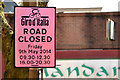
Giro d'Italia "road closed" notice, Ballyhackamore, Belfast (April 2014)
A notice, at the Upper Newtownards end of Eastleigh Drive, giving the times of the closure of the Upper Newtownards Road for the practice session (morning) and the team time trails (evening). The route includes the Upper Newtownards Road to and from Stormont. This photograph appears as a matter of historical record only. I have no connection with the race.
Image: © Albert Bridge
Taken: 23 Apr 2014
0.02 miles
8
Library Court, Ballyhackamore, Belfast (August 2015)
See Image (August 2013). The shops on the Eastleigh Drive side of the building.
Image: © Albert Bridge
Taken: 9 Aug 2015
0.02 miles
9
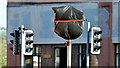
Covered road sign, Ballyhackamore, Belfast (August 2015)
A new road sign, the identity of which is hidden by plastic sheeting, at the Upper Newtownards Road end of Eastleigh Drive – one of several erected recently.
Image: © Albert Bridge
Taken: 3 Aug 2015
0.02 miles
10
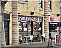
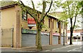
Piggly Wigglys, Ballyhackamore, Belfast (September 2016)
Very long-established café/coffee shop on the Eastleigh Drive side of Library Court http://www.geograph.org.uk/search.php?i=66056416. This photograph appears as a matter of record only. I have no connection with the business.
Image: © Albert Bridge
Taken: 18 Sep 2016
0.02 miles