IMAGES TAKEN NEAR TO
Duncrue Street, BELFAST, BT3 9BJ
Introduction
This page details the photographs taken nearby to Duncrue Street, BT3 9BJ by members of the Geograph project.
The Geograph project started in 2005 with the aim of publishing, organising and preserving representative images for every square kilometre of Great Britain, Ireland and the Isle of Man.

There are currently over 7.5m images from over14,400 individuals and you can help contribute to the project by visiting https://www.geograph.org.uk
Image Map
Images are licensed for reuse under creativecommons.org/licenses/by-sa/2.0
Notes
- Clicking on the map will re-center to the selected point.
- The higher the marker number, the further away the image location is from the centre of the postcode.
Image Listing (56 Images Found)
Images are licensed for reuse under creativecommons.org/licenses/by-sa/2.0
Image
Details
Distance
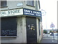
1
Duncrue Street, Belfast (1)
Warehouses, vacant and occupied, at the southern end of Duncrue Street. Belfast harbour is behind the fence on the right. The footpath, on the eastern side, is under reconstruction.
Image: © Albert Bridge
Taken: 2 Dec 2011
0.02 miles
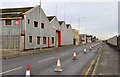
2
Vacant commercial site, Belfast
Part of a vacant commercial site on the western side of Duncrue Street. The lower third of the photograph has what seems to be a disused railway Image
Image: © Albert Bridge
Taken: 2 Dec 2011
0.04 miles
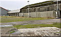
3
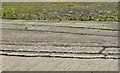
Old narrow gauge railway? Belfast
See Image Part of the same site (just out of picture to the right), looking through a palisade fence at what seems to be two narrow gauge railway sidings. They are visible in the lower part of the previous photograph.
Not mentioned in the otherwise comprehensive “Johnson’s [railway] Atlas and Gazetteer”. 100 years ago this part of Duncrue Street was used by several businesses connected with the timber trade. At a guess (and I might be completely wrong) it’s possible that they were part of an internal horse-drawn tramway.
Image: © Albert Bridge
Taken: 2 Dec 2011
0.05 miles
4
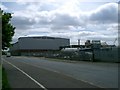
Warehouse
At Duncrue Street Industrial Estate.
Image: © Paul McIlroy
Taken: 1 Jun 2006
0.07 miles
5
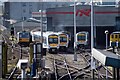
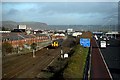
Railway Depot
NIR Railway Depot at York Road. Image made from the Milewater Road footbridge that spans the M2 motorway and Larne Line railway line.
Image: © Wilson Adams
Taken: 9 Apr 2006
0.07 miles
6
A railcar passes
Image made from the Milewater Road footbridge
Image: © Wilson Adams
Taken: 3 Apr 2006
0.07 miles
7
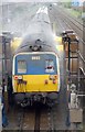
Washing the coaches
Train passing through the carriage washer at York Rd. I just hope the driver remembered to close the window :-).
Image: © Wilson Adams
Taken: 21 Apr 2005
0.07 miles
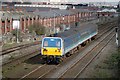
8
The Larne Railway Line and M2 Motorway
The Larne Railway Line and M2 Motorway looking towards Fortwilliam.
Image made from the Milewater Road footbridge.
Image: © Wilson Adams
Taken: 13 Nov 2006
0.07 miles
9
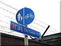
National Cycle Network route signage
Directional NCN route sign also indicating that it is on a stretch of path designated "shared use with pedestrians"
Image: © Robert Ashby
Taken: 1 Oct 2012
0.07 miles