IMAGES TAKEN NEAR TO
Beechview, BALLYCLARE, BT39 9XT
Introduction
This page details the photographs taken nearby to Beechview, BT39 9XT by members of the Geograph project.
The Geograph project started in 2005 with the aim of publishing, organising and preserving representative images for every square kilometre of Great Britain, Ireland and the Isle of Man.

There are currently over 7.5m images from over14,400 individuals and you can help contribute to the project by visiting https://www.geograph.org.uk
Image Map
Images are licensed for reuse under creativecommons.org/licenses/by-sa/2.0
Notes
- Clicking on the map will re-center to the selected point.
- The higher the marker number, the further away the image location is from the centre of the postcode.
Image Listing (17 Images Found)
Images are licensed for reuse under creativecommons.org/licenses/by-sa/2.0
Image
Details
Distance
1
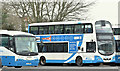
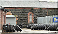
Buses, Ballyclare (January 2017)
Of the several buses parked in the yard at Ballyclare bus station Image these two were the easiest to photograph (through the closed and locked gates) – (left) Irizar-bodied Scania (1699/TCZ 1699) and a Wright-bodied Volvo (2278/PEZ 7278).
Image: © Albert Bridge
Taken: 8 Jan 2017
0.12 miles
2
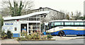
Ballyclare bus station (January 2017)
Ballyclare Ulsterbus station close to the Mill Road. In keeping with practice from the days of the Belfast and Northern Counties Railway it’s close to the site of the old railway station (just out of picture in the left background).
The main service is an hourly express to Belfast and Larne (19 M/F - less frequent on Saturdays and just three on a Sunday).
Image: © Albert Bridge
Taken: 8 Jan 2017
0.13 miles
3
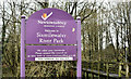
Sixmilewater Park sign, Ballyclare (January 2016)
The old Newtownabbey District Council sign, at the entrance to the Sixmilewater Park Image, on the Mill Road.
Image: © Albert Bridge
Taken: 8 Jan 2017
0.15 miles
4
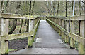
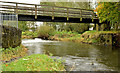
Boardwalk, Sixmilewater Park, Ballyclare (January 2017)
An elevated boardwalk, across damp ground, at the entrance to the Sixmilewater Park Image
Image: © Albert Bridge
Taken: 8 Jan 2017
0.15 miles
5
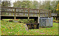
The Sixmilewater, Ballyclare (3)
The Sixmilewater, looking upstream, beside the old mill race Image (just out of picture to the left). The footbridge connects Avondale Drive and the Mill Road. The river is not shown on the Google map – see the satellite photograph.
Image: © Albert Bridge
Taken: 28 Oct 2012
0.16 miles
6
Old mill race and sluice, Ballyclare
The remains of an old mill race and sluice beside the Sixmilewater (right) Image To the best of my knowledge they powered the paper mill (1875-1950) which was served by a siding on the (3ft) narrow-gauge railway Image from Ballyboley Jct, between Ballymena and Larne. The line closed to passengers in 1930 but continued to operate goods trains to the paper mill until its closure. The river is not shown on the Google map – see the satellite photograph.
Image: © Albert Bridge
Taken: 28 Oct 2012
0.16 miles
7
Former railway goods shed, Ballyclare - January 2017(2)
See Image A side view from the Mill Road
Image: © Albert Bridge
Taken: 8 Jan 2017
0.16 miles
8

The Ballyclare bypass (1979)
A winter view of a deserted Ballyclare bypass, looking towards Templepatrick, from the flyover on the Hillhead Road Image
Image: © Albert Bridge
Taken: 9 Dec 1979
0.17 miles
9
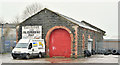
Former railway goods shed, Ballyclare - January 2017(1)
Ballyclare was the terminus of a 3½ mile branch (1884/1950) from Kingsbog Jct Image and Image The line closed to passengers in 1938 and to goods in 1950. This view, from the Hillhead Road, shows the old goods shed still in commercial use. Image shows a side view from the Mill Road.
Image: © Albert Bridge
Taken: 8 Jan 2017
0.17 miles
10
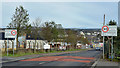
30 mph signs, Ballyclare (March 2016)
The start of the 30 mph zone, entering Ballyclare from Belfast, along the Hillhead Road.
Image: © Albert Bridge
Taken: 6 Mar 2016
0.18 miles