IMAGES TAKEN NEAR TO
Chisholm Mews, BALLYCLARE, BT39 9FN

Introduction

This page details the photographs taken nearby to Chisholm Mews, BT39 9FN by members of the Geograph project.

The Geograph project started in 2005 with the aim of publishing, organising and preserving representative images for every square kilometre of Great Britain, Ireland and the Isle of Man.

There are currently over 7.5m images from over14,400 individuals and you can help contribute to the project by visiting https://www.geograph.org.uk

Image Map


Images are licensed for reuse under creativecommons.org/licenses/by-sa/2.0
Notes
  • Clicking on the map will re-center to the selected point.
  • The higher the marker number, the further away the image location is from the centre of the postcode.

Image Listing (18 Images Found)

Images are licensed for reuse under creativecommons.org/licenses/by-sa/2.0
Image
Details
Distance
1
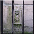
Flush Bracket, Ballyclare
Flush bracket bench mark on the north-eastern corner of Ballyclare Town Hall Image The number on the bracket is OSBM 3491 (a bit fuzzy as it is partially covered over and enclosed by two sets of railings - this was taken with a long zoom lens). The mark has been levelled to 74.05 metres above MSL.
Image: © Rossographer Taken: 15 Jun 2014
0.12 miles
2
Ballyclare Town Hall
Town hall in the centre of Ballyclare.
Image: © Rossographer Taken: 15 Jun 2014
0.13 miles
3
Two clocks, Ballyclare
Two clocks, not adjusted for GMT but otherwise accurate, on the Town Hall, The Square Image
Image: © Albert Bridge Taken: 28 Oct 2012
0.13 miles
4
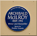
Archibald McIlroy plaque, Ballyclare
A plaque, on the Town Hall, The Square Image, commemorating the locally-born writer Archibald McIlroy http://www.ulsterhistory.co.uk/mcilroy.html. He died in the sinking of the “Lusitania” http://www.geograph.org.uk/search.php?i=37360202.
Image: © Albert Bridge Taken: 28 Oct 2012
0.13 miles
5
Wall and corner protection, Ballyclare
Anonymous metal wall and corner protection opposite the Harrier Way car park.
Image: © Albert Bridge Taken: 28 Oct 2012
0.14 miles
6
Ballyclare, County Antrim
Heading north-west towards the town centre.
Image: © Kenneth Allen Taken: 27 Jan 2007
0.14 miles
7
Pillar box and telephone boxes, Ballyclare
Two telephone boxes and an EIIR pillar box (BT39 203) at The Square.
Image: © Albert Bridge Taken: 28 Oct 2012
0.14 miles
8
The Central Dining Rooms, Ballyclare - January 2017(2)
See Image An inscription showing the building’s original name.
Image: © Albert Bridge Taken: 8 Jan 2017
0.17 miles
9
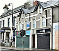
The Central Dining Rooms, Ballyclare - January 2017(1)
The Central Dining Rooms at 49-51 Main Street, next to the Ulster Bank Image (left). Apparently unchanged above the ground floor (save for the glazing) the building is not listed but the official description contains this “Attached two-storey two-bay former ‘Central Dining Rooms’ building, built c.1830, located to south of Main Street . . . . . The building appears on the first edition OS map of the area (1833) as part of the terrace of buildings that make up Main Street. Originally the building was a shop to the ground floor, with dwelling above.” Image shows the building’s name.
Image: © Albert Bridge Taken: 8 Jan 2017
0.17 miles
10
The Ulster Bank, Ballyclare - January 2017(2)
See Image Four of the nine chimney pots. Banks had upstairs accommodation for the manager and his family in addition to the downstairs offices – all of which were heated by burning coal.
Image: © Albert Bridge Taken: 8 Jan 2017
0.18 miles