IMAGES TAKEN NEAR TO
Mill Road, BALLYCLARE, BT39 9DR
Introduction
This page details the photographs taken nearby to Mill Road, BT39 9DR by members of the Geograph project.
The Geograph project started in 2005 with the aim of publishing, organising and preserving representative images for every square kilometre of Great Britain, Ireland and the Isle of Man.

There are currently over 7.5m images from over14,400 individuals and you can help contribute to the project by visiting https://www.geograph.org.uk
Image Map
Images are licensed for reuse under creativecommons.org/licenses/by-sa/2.0
Notes
- Clicking on the map will re-center to the selected point.
- The higher the marker number, the further away the image location is from the centre of the postcode.
Image Listing (33 Images Found)
Images are licensed for reuse under creativecommons.org/licenses/by-sa/2.0
Image
Details
Distance
1
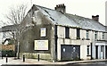
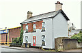
Development site, 3 Main Street, Ballyclare (January 2017)
A derelict property at the roundabout (south eastern) end of Main Street. The gable sign advises “With full planning permission 1 x bedroom apartment & 1 x retail unit”. This photograph appears as a matter of record only. I have no connection with any of the parties involved in the sale.
Image: © Albert Bridge
Taken: 8 Jan 2017
0.02 miles
2
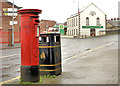
Pillar box, Ballyclare
GR pillar box (BT39 228), close to the roundabout on the Ballynure Road. Image shows the same box after being moved.
Image: © Albert Bridge
Taken: 28 Oct 2012
0.02 miles
3
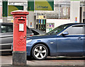
Pillar box BT39 228, Ballyclare (January 2017)
This GR pillar box (BT39 228) Image now moved to the Costcutter/post office on the Ballynure Road Image
Image: © Albert Bridge
Taken: 8 Jan 2017
0.05 miles
4
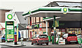
Post office and petrol station, Ballyclare (January 2017)
BP petrol station, Costcutter supermarket and post office on the Ballynure Road. The building also has rooftop solar panels (upper right). Image shows the pillar box (lower left).
Image: © Albert Bridge
Taken: 8 Jan 2017
0.06 miles
5
Disguised building, Ballyclare (January 2017)
A disguised and derelict building, on the Mill Road, close to the entrance to the bus station.
Image: © Albert Bridge
Taken: 8 Jan 2017
0.06 miles
6
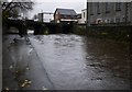
The Sixmilewater, Ballyclare
The Sixmilewater as it passes through Ballyclare. After recent rain the water level is very high and just beginning to burst onto the path alongside.
Image: © Rossographer
Taken: 19 Nov 2009
0.07 miles
7
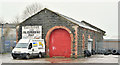
Former railway goods shed, Ballyclare - January 2017(1)
Ballyclare was the terminus of a 3½ mile branch (1884/1950) from Kingsbog Jct Image and Image The line closed to passengers in 1938 and to goods in 1950. This view, from the Hillhead Road, shows the old goods shed still in commercial use. Image shows a side view from the Mill Road.
Image: © Albert Bridge
Taken: 8 Jan 2017
0.07 miles
8
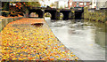
The Sixmilewater, Ballyclare (2)
See Image (November 2009). Just under three years later and another rainy day. The view is upstream towards the Town Bridge with a covering of wet autumn leaves on the path (left). The river is not shown on the Google map – see the satellite photograph.
Image: © Albert Bridge
Taken: 28 Oct 2012
0.07 miles
9
Former railway goods shed, Ballyclare - January 2017(2)
See Image A side view from the Mill Road
Image: © Albert Bridge
Taken: 8 Jan 2017
0.08 miles
10
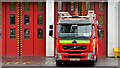
Fire appliance, Ballyclare
A Browns-bodied Volvo, outside Ballyclare fire station, on the Ballynure Road.
Image: © Albert Bridge
Taken: 28 Oct 2012
0.08 miles