IMAGES TAKEN NEAR TO
Slaughterford Road, CARRICKFERGUS, BT38 9TG
Introduction
This page details the photographs taken nearby to Slaughterford Road, BT38 9TG by members of the Geograph project.
The Geograph project started in 2005 with the aim of publishing, organising and preserving representative images for every square kilometre of Great Britain, Ireland and the Isle of Man.

There are currently over 7.5m images from over14,400 individuals and you can help contribute to the project by visiting https://www.geograph.org.uk
Image Map
Images are licensed for reuse under creativecommons.org/licenses/by-sa/2.0
Notes
- Clicking on the map will re-center to the selected point.
- The higher the marker number, the further away the image location is from the centre of the postcode.
Image Listing (28 Images Found)
Images are licensed for reuse under creativecommons.org/licenses/by-sa/2.0
Image
Details
Distance
1
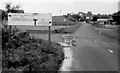
Pre-Worboys sign, Whitehead
A pre-Worboys sign on the Slaughterford Road, leading to the main road. The crossroads Image had still to be re-built. The Rawbrae service station is at top right and still looks much the same.
Image: © Albert Bridge
Taken: 6 Jul 1980
0.04 miles
2
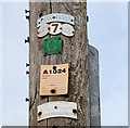
Telegraph pole, Whitehead
See Image Similar signs on a pole on the Slaughterford Road, opposite Brooklands Park. Continue to Image
Image: © Albert Bridge
Taken: 17 Mar 2010
0.05 miles
3
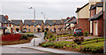
Riverforde, Whitehead (1)
Recent development off the Slaughterford Road. See also Image
Image: © Albert Bridge
Taken: 23 Feb 2011
0.05 miles
4
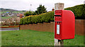
Letter box, Whitehead
Post-mounted EIIR letter box, on the Slaughterford Road, near the entrance to Brooklands Park (background).
Image: © Albert Bridge
Taken: 23 Feb 2011
0.05 miles
5
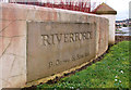
Riverforde, Whitehead (2)
The “street sign”, at the entrance to Riverforde Image, on the Slaughterford Road.
Image: © Albert Bridge
Taken: 23 Feb 2011
0.05 miles
6
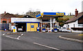
The Raw Brae Service Station, Whitehead
On the Larne Road opposite the Slaughterford Road. One of the last of its type.
Image: © Albert Bridge
Taken: 17 Mar 2010
0.11 miles
7
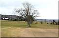
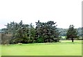
Bentra golf course, Whitehead
The 9-hole municipal course seen from the Slaughterford Road. Continue to Image
Image: © Albert Bridge
Taken: 17 Mar 2010
0.11 miles
8
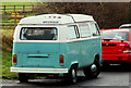
Volkswagen Westfalia, Whitehead
Volkswagen produced the “T1” and “T2” motor homes/camper vans between 1950 and 1979. The “Westfalia” was a conversion produced by the Westfalia-Werke. This seems to be a 1979 model.
Image: © Albert Bridge
Taken: 23 Feb 2011
0.11 miles
10
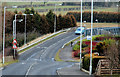
The Slaughterford Road, Whitehead
The Slaughterford Road runs from the Carrickfergus-Larne road to Whitehead. This view is towards Whitehead across the Slaughterford bridges Image The origin of the name lies in circumstances, the story behind which might not be entirely accurate. Consult the Ordnance Survey Memoirs.
Image: © Albert Bridge
Taken: 17 Mar 2010
0.12 miles