IMAGES TAKEN NEAR TO
Larne Road, CARRICKFERGUS, BT38 9BN
Introduction
This page details the photographs taken nearby to Larne Road, BT38 9BN by members of the Geograph project.
The Geograph project started in 2005 with the aim of publishing, organising and preserving representative images for every square kilometre of Great Britain, Ireland and the Isle of Man.

There are currently over 7.5m images from over14,400 individuals and you can help contribute to the project by visiting https://www.geograph.org.uk
Image Map
Images are licensed for reuse under creativecommons.org/licenses/by-sa/2.0
Notes
- Clicking on the map will re-center to the selected point.
- The higher the marker number, the further away the image location is from the centre of the postcode.
Image Listing (12 Images Found)
Images are licensed for reuse under creativecommons.org/licenses/by-sa/2.0
Image
Details
Distance
1
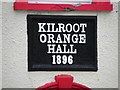
Plaque, Kilroot Orange Hall
It is located here Image]
Image: © Kenneth Allen
Taken: 1 Jun 2010
0.03 miles
2
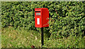
Postbox BT38 200, Kilroot, Carrickfergus (July 2017)
Post-mounted pressed-steel postbox (BT38 200), on the Larne Road, opposite the Station Road.
Image: © Albert Bridge
Taken: 20 Jul 2017
0.05 miles
4
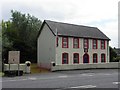
Kilroot Orange Hall, Eden
Pictured along the Larne Road and built in 1896
See close-up of plaque here Image]
Image: © Kenneth Allen
Taken: 1 Jun 2010
0.08 miles
5
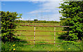
Gate, Kilroot, Carrickfergus
A field gate on the Larne Road. The pylons and power lines (seen in Image from a different viewpoint) originate at Kilroot power station Image - behind me.
Image: © Albert Bridge
Taken: 6 May 2010
0.08 miles
6
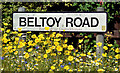
Beltoy Road name sign, Kilroot, Carrickfergus (July 2017)
Name sign, surrounded by wildflowers, at the Larne Road end of the Beltoy Road Image The townland (not shown) is Dobbsland.
Image: © Albert Bridge
Taken: 20 Jul 2017
0.14 miles
7
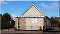
Eden gospel hall near Carrickfergus
Gospel hall, on the Larne Road Image, Eden.
Image: © Albert Bridge
Taken: 6 May 2010
0.18 miles
8
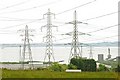
Pylons and power lines near Carrickfergus (2)
See Image More lines and pylons to the south east of the Beltoy Road Image with part of Kilroot power station Image visible at lower right.
Image: © Albert Bridge
Taken: 12 Jun 2009
0.20 miles
9
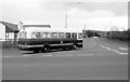
A Road Junction
A bus turning left from the Larne Rd unto the Beltoy Road at Eden.
Image: © Wilson Adams
Taken: 27 Apr 1996
0.21 miles
10
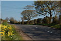
The Beltoy Road near Carrickfergus
The Beltoy Road runs off the Carrickfergus – Larne road at Eden and forms part of the back road to Larne. The overhead electricity cables are common here with Kilroot power station Image near the bottom of the road and Ballylumford Image power station not too far away.
Image: © Albert Bridge
Taken: 12 Apr 2007
0.21 miles