IMAGES TAKEN NEAR TO
Shore Road, CARRICKFERGUS, BT38 8UB
Introduction
This page details the photographs taken nearby to Shore Road, BT38 8UB by members of the Geograph project.
The Geograph project started in 2005 with the aim of publishing, organising and preserving representative images for every square kilometre of Great Britain, Ireland and the Isle of Man.

There are currently over 7.5m images from over14,400 individuals and you can help contribute to the project by visiting https://www.geograph.org.uk
Image Map
Images are licensed for reuse under creativecommons.org/licenses/by-sa/2.0
Notes
- Clicking on the map will re-center to the selected point.
- The higher the marker number, the further away the image location is from the centre of the postcode.
Image Listing (92 Images Found)
Images are licensed for reuse under creativecommons.org/licenses/by-sa/2.0
Image
Details
Distance
1
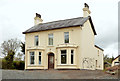
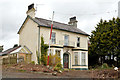
Vested house, Greenisland (2013-4)
A large detached house, on the Belfast side of Neill’s Lane, now vacant and awaiting demolition. The line for the new road is in the foreground. Also seen (left) in Image
Image: © Albert Bridge
Taken: 4 May 2013
0.03 miles
2
Houses, Jordanstown/Greenisland (2)
Vacant and boarded-up house, on the Carrickfergus side of this lane Image, awaiting demolition to make way for the new road.
Image: © Albert Bridge
Taken: 16 Feb 2012
0.03 miles
3
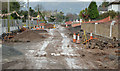
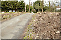
Road construction, Jordanstown/Greenisland (3)
The Shore Road under reconstruction, looking towards Belfast, at Neill’s Lane. The site was previously the gardens of the houses on the right.
Image: © Albert Bridge
Taken: 1 Dec 2013
0.03 miles
4
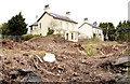
Vested houses, Greenisland (2013-3)
Two detached houses, on the Belfast side of Neill’s Lane, now vacant and awaiting demolition. The cleared line for the new road occupies most of the foreground. The view is from the Shore Road at this lane Image Image and Image shows them individually.
Image: © Albert Bridge
Taken: 4 May 2013
0.03 miles
5
Lane, Greenisland (2013-1)
This lane Image, on the Belfast side of Neill’s Lane, where the reserved line has been cleared of vegetation.
Image: © Albert Bridge
Taken: 4 May 2013
0.03 miles
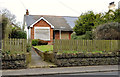
6
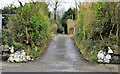
Lane, Jordanstown/Greenisland
A lane, off the Shore Road, on the Carrickfergus side of Image, which has (I think) the postal address of “Shore Road, Greenisland”). Most of this scene will disappear when work starts on the new road.
Image: © Albert Bridge
Taken: 16 Feb 2012
0.03 miles
7
Vested house, Greenisland (2013-5)
A large detached house, on the Belfast side of Neill’s Lane, now vacant and awaiting demolition. The line for the new road is in the foreground. Also seen (right) in Image
Image: © Albert Bridge
Taken: 4 May 2013
0.04 miles
8
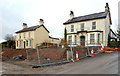
Vacant houses, Greenisland
Two vacant houses Image and Image, at the corner of the Shore Road and Neill’s Lane, overlooking the sight of their gardens Image being rebuilt as the outward lanes of the new dual carriageway.
Image: © Albert Bridge
Taken: 1 Dec 2013
0.04 miles
9
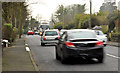
The Shore Road, Jordanstown/Greenisland (11)
The Shore Road (looking towards Belfast) from opposite Neill’s Lane Image This photograph shows why the new road is needed.
Image: © Albert Bridge
Taken: 16 Feb 2012
0.04 miles
10
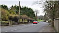
The Shore Road, Jordanstown/Greenisland (9)
The Shore Road, looking towards Carrickfergus. Shorelands is in the background, to the left of the blue car, beside the traffic cones.
Image: © Albert Bridge
Taken: 16 Feb 2012
0.04 miles