IMAGES TAKEN NEAR TO
Shore Road, CARRICKFERGUS, BT38 8TZ
Introduction
This page details the photographs taken nearby to Shore Road, BT38 8TZ by members of the Geograph project.
The Geograph project started in 2005 with the aim of publishing, organising and preserving representative images for every square kilometre of Great Britain, Ireland and the Isle of Man.

There are currently over 7.5m images from over14,400 individuals and you can help contribute to the project by visiting https://www.geograph.org.uk
Image Map
Images are licensed for reuse under creativecommons.org/licenses/by-sa/2.0
Notes
- Clicking on the map will re-center to the selected point.
- The higher the marker number, the further away the image location is from the centre of the postcode.
Image Listing (21 Images Found)
Images are licensed for reuse under creativecommons.org/licenses/by-sa/2.0
Image
Details
Distance
1
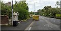
The Shore Road at Greenisland
The old A2, now relegated to just the Shore Road by the new bypass, though virtually traffic-free.
Image: © Rossographer
Taken: 27 Aug 2024
0.04 miles
2
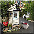
Community Library, Greenisland
A little community library on the Shore Road, Greenisland.
Image: © Rossographer
Taken: 27 Aug 2024
0.06 miles
3
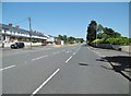
Greenisland, Shore Road
The original A2; the suburb has now been by-passed to the North.
Image: © Mike Faherty
Taken: 2 Jul 2018
0.07 miles
4
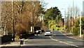
The Shore Road near Greenisland (1)
See Image The road, in this square, looking towards Belfast. This section is expected to be bypassed by the new road.
Image: © Albert Bridge
Taken: 22 Mar 2008
0.08 miles
5
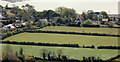
Proposed road, Greenisland (3)
The view from Knockagh war memorial Image towards the Shore Road, Greenisland. The proposed dual carriageway is due to run off-line from the Station Road to Seapark. My understanding, from the small scale map available, is that the road will pass towards the middle/bottom right and cross Whinfield Lane (the houses on the left) without affecting them. The map shows the north western end of Whinfield Lane crossing the dual carriageway by a bridge although whether it is a footbridge or a road bridge is not clear.
The new road will then curve back towards the Shore Road at Seapark.
Image: © Albert Bridge
Taken: 16 May 2012
0.10 miles
6
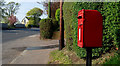
Letter box, Greenisland
Post-mounted EIIR letter box (BT38 668), on the Shore Road, between Greenisland and Seapark. Note added 29 December 2013: now removed to facilitate the building of the new dual carriageway.
Image: © Albert Bridge
Taken: 20 Apr 2011
0.12 miles
7
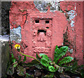
Flush Bracket near Carrickfergus
Flush bracket bench mark located on the front wall of a house close to the A2 Belfast Road. The house now appears to be part of a car sales business.
The number on the bracket is OSBM 3392.
The mark has been levelled to 7.40 metres above MSL.
A flush bracket is a type of bench mark set onto the face of a building. See also http://www.geograph.org.uk/search.php?i=11037856 for many other examples I have found.
Image: © Rossographer
Taken: 18 Jun 2011
0.13 miles
8
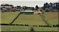
Proposed road, Greenisland (2)
The view from Knockagh war memorial Image towards the Shore Road, Greenisland. The proposed dual carriageway is due to run off-line from the Station Road to Seapark. My understanding, from the small scale map available, is that it will occupy the area on this side of the houses (top) passing through the warehouses Image (upper middle).
Image: © Albert Bridge
Taken: 16 May 2012
0.15 miles
9
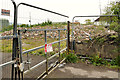
Rubble, Greenisland
A pile of rubble (part of which can be seen (foreground) in Image) from buildings demolished to make way for the proposed new dual carriageway. This section of the proposed road, between the Station Road and Seapark, is due to run off-line on the north western side of the existing Shore Road.
Image: © Albert Bridge
Taken: 2 May 2012
0.17 miles
10
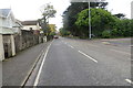
Shore Road
Section of the once busy Shore Road which has been by-passed by the now completed A2 dual carriageway, leaving it in peaceful isolation.
Image: © Robert Ashby
Taken: 28 Oct 2015
0.17 miles