IMAGES TAKEN NEAR TO
Victoria Road, CARRICKFERGUS, BT38 7JJ
Introduction
This page details the photographs taken nearby to Victoria Road, BT38 7JJ by members of the Geograph project.
The Geograph project started in 2005 with the aim of publishing, organising and preserving representative images for every square kilometre of Great Britain, Ireland and the Isle of Man.

There are currently over 7.5m images from over14,400 individuals and you can help contribute to the project by visiting https://www.geograph.org.uk
Image Map
Images are licensed for reuse under creativecommons.org/licenses/by-sa/2.0
Notes
- Clicking on the map will re-center to the selected point.
- The higher the marker number, the further away the image location is from the centre of the postcode.
Image Listing (14 Images Found)
Images are licensed for reuse under creativecommons.org/licenses/by-sa/2.0
Image
Details
Distance
1
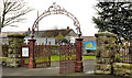
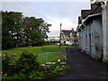
Gates, Victoria cemetery, Carrickfergus (1)
Wrought-iron gates and archway, at the entrance to Victoria Cemetery on the Victoria Road. It opened in 1904 with financial assistance from Hugh Legg Image Now much extended on the northern side. For more information see http://www.historyfromheadstones.com/index.php?displaygraveyardinfo&graveyard_name=Victoria%20Cemetery Continue to Image
Image: © Albert Bridge
Taken: 30 Nov 2011
0.16 miles
2
Gates, Victoria cemetery, Carrickfergus (2)
Image: © Albert Bridge
Taken: 30 Nov 2011
0.16 miles
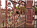
3
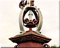
Gates, Victoria cemetery, Carrickfergus (3)
See Image Detail from a gatepost (looking out towards the Victoria Road).
Image: © Albert Bridge
Taken: 30 Nov 2011
0.16 miles
4
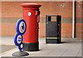
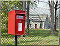
Pillar box, Carrickfergus
EIIR pillar box outside Victoria Road post office.
Image: © Albert Bridge
Taken: 30 Nov 2011
0.18 miles
5
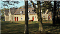
Shiels Almshouses, Carrickfergus
Frontage and gardens of part of the almshouses in Carrickfergus. see Image for a full explanation.
Image: © Rossographer
Taken: 18 Jun 2011
0.19 miles
6
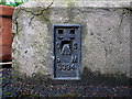
Flush Bracket, Carrickfergus
Flush bracket bench mark located on the bottom of the main tower at Shiels Almshouses, Carrickfergus Image
The number on the bracket is OSBM 3394.
The mark has been levelled to 12.85 metres above MSL.
A flush bracket is a type of bench mark set onto the face of a building. See also http://www.geograph.org.uk/search.php?i=11037856 for many other examples I have found.
Image: © Rossographer
Taken: 18 Jun 2011
0.21 miles
7
The Shiels Almshouses, Carrickfergus
See Image and Image The building in the days when the residents had the luxury of a horse grazing in the grounds.
Image: © Albert Bridge
Taken: 23 Oct 1982
0.23 miles
8
Postbox BT38 350, Carrickfergus (May 2017)
A pressed-steel postbox (BT38 350) on the Downshire Road, at the side of the Shiels Almshouses. It replaced this one Image
Image: © Albert Bridge
Taken: 10 May 2017
0.24 miles
9
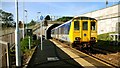
Departure from Downshire station
See Image The 10.27 from Larne Harbour departing Downshire for Belfast (Gt Victoria Street).
Image: © Albert Bridge
Taken: 11 Oct 2008
0.24 miles
10
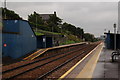
Downshire station, Carrickfergus (1)
Originally there were four stations between Carrickfergus and Whitehead. Only Downshire survives. Most of the traffic is to or from the Belfast direction. This is the view towards Whitehead and Larne.
Image: © Albert Bridge
Taken: 5 Sep 2006
0.25 miles