IMAGES TAKEN NEAR TO
Patterson Drive, CARRICKFERGUS, BT38 7ER
Introduction
This page details the photographs taken nearby to Patterson Drive, BT38 7ER by members of the Geograph project.
The Geograph project started in 2005 with the aim of publishing, organising and preserving representative images for every square kilometre of Great Britain, Ireland and the Isle of Man.

There are currently over 7.5m images from over14,400 individuals and you can help contribute to the project by visiting https://www.geograph.org.uk
Image Map
Images are licensed for reuse under creativecommons.org/licenses/by-sa/2.0
Notes
- Clicking on the map will re-center to the selected point.
- The higher the marker number, the further away the image location is from the centre of the postcode.
Image Listing (40 Images Found)
Images are licensed for reuse under creativecommons.org/licenses/by-sa/2.0
Image
Details
Distance
1
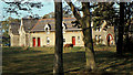
The Shiels Almshouses, Carrickfergus
See Image and Image The building in the days when the residents had the luxury of a horse grazing in the grounds.
Image: © Albert Bridge
Taken: 23 Oct 1982
0.07 miles
2
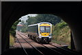
Approaching Downshire station
Downshire station is crossed, at the Belfast end, by the Carrickfergus-Larne road. The 10.35 Belfast Central-Larne Harbour is framed by the road bridge as it approaches the platform.
Image: © Albert Bridge
Taken: 5 Sep 2006
0.10 miles
3
New bridge, Downshire station, Carrickfergus
See Image (April 1997). Four months later the bridge has been built and work is underway on the construction of the Larne Road on top.
Image: © Albert Bridge
Taken: 16 Aug 1997
0.10 miles
4
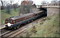
Bridge, Downshire station, Carrickfergus
The 13.18 Larne Harbour – Belfast York Road passing under the Larne Road at Downshire station. The bridge can also be seen (background) in Image (March 1980).
Image: © Albert Bridge
Taken: 9 Apr 1985
0.11 miles
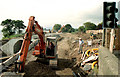
5
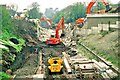
Bridge demolition, Carrickfergus
The bridge, carrying the Carrickfergus – Larne road, across the railway at Downshire station, was replaced in early 1997. Demolition took place over the weekend of 5/6 April. In this photo the reinforced concrete span has gone but the abutments remain. The road and railway were both closed for the duration. Image shows the replacement bridge. Both views are towards Barn/Carrickfergus. Continue to Image
Image: © Albert Bridge
Taken: 6 Apr 1997
0.11 miles
6
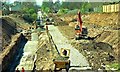
Bridge demolition, Carrickfergus (3)
See Image Just six days later and all traces of the old bridge have gone. The foundations for the new abutment can be seen (left) while (right) ballast for the new railway formation has been laid. Continue to Image (August 1997).
Image: © Albert Bridge
Taken: 12 Apr 1997
0.12 miles
7
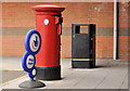
Pillar box, Carrickfergus
EIIR pillar box outside Victoria Road post office.
Image: © Albert Bridge
Taken: 30 Nov 2011
0.12 miles
8
Downshire station, Carrickfergus (3)
See Image A concreted area, at the bottom of the steps on the up platform, which has the appearance of the base for a new passenger shelter.
Image: © Albert Bridge
Taken: 9 Oct 2011
0.12 miles
9
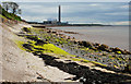
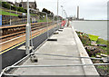
The shore at Carrickfergus (2)
See Image The shore, from the same spot, but looking towards Downshire and Kilroot power station.
Image: © Albert Bridge
Taken: 6 May 2010
0.12 miles
10
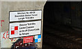
Tunnel sign, Downshire station
Self-explanatory warning sign at the entrance to the tunnel Image, under the Larne Road, at Downshire station. 78.65 metres works out at almost exactly 86 yards.
Image: © Albert Bridge
Taken: 20 Apr 2011
0.12 miles