IMAGES TAKEN NEAR TO
Downshire Avenue, CARRICKFERGUS, BT38 7EL
Introduction
This page details the photographs taken nearby to Downshire Avenue, BT38 7EL by members of the Geograph project.
The Geograph project started in 2005 with the aim of publishing, organising and preserving representative images for every square kilometre of Great Britain, Ireland and the Isle of Man.

There are currently over 7.5m images from over14,400 individuals and you can help contribute to the project by visiting https://www.geograph.org.uk
Image Map
Images are licensed for reuse under creativecommons.org/licenses/by-sa/2.0
Notes
- Clicking on the map will re-center to the selected point.
- The higher the marker number, the further away the image location is from the centre of the postcode.
Image Listing (34 Images Found)
Images are licensed for reuse under creativecommons.org/licenses/by-sa/2.0
Image
Details
Distance
1
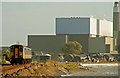
Railway at Downshire
The railway follows the shore of Belfast Lough between Whitehead and Downshire Image The 10.27 Larne Harbour – Belfast (Gt Victoria Street) is approaching Downshire station. Kilroot power station Image dominates the background.
Image: © Albert Bridge
Taken: 11 Oct 2008
0.04 miles
2
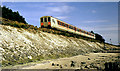
Railway at Downshire (2)
The railway runs very close to the shore on the approach to Downshire station. The tide was well out but comes up to the embankment (since strengthened) at high water. The train is the 12.55 Whitehead – Belfast York Road.
Image: © Albert Bridge
Taken: 2 Jul 1987
0.04 miles
3
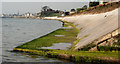
The loughshore near Carrickfergus (2)
The shore of Belfast Lough, at Boneybefore, just under an hour before high water. This drain Image is in the foreground. The Belfast – Larne railway is hidden above the seawall on the right.
Image: © Albert Bridge
Taken: 20 Apr 2011
0.05 miles
4
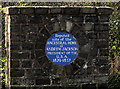
Andrew Jackson plaque, Carrickfergus
Image: © Albert Bridge
Taken: 20 Apr 2011
0.06 miles
5
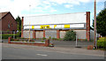
Former Downshire Motors, Carrickfergus
The former Downshire Motors site (there is another on the other side of the road), on the Larne Road, has been vacant for a number of years.
Image: © Albert Bridge
Taken: 6 May 2010
0.07 miles
6
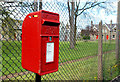
Letter box, Carrickfergus
Post-mounted EIIR box, on the Downshire Road, at the side of the Shiels Almshouses Image Image shows the pressed-steel replacement.
Image: © Albert Bridge
Taken: 6 May 2010
0.07 miles
7
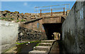
Railway bridge, Boneybefore, Carrickfergus
An underbridge at Boneybefore, dated 1926 (Image explains) across a path and drain running to the shore of Belfast Lough.
Image: © Albert Bridge
Taken: 20 Apr 2011
0.08 miles
8
Railway milepost near Downshire, Carrickfergus
Translink milepost 10¾ (from Belfast York Road Image), on the Larne side of Downshire station, seen from a well-worn path on the seaward side of an unfenced stretch of the line.
Image: © Albert Bridge
Taken: 20 Apr 2011
0.09 miles
9
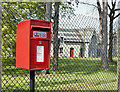
Postbox BT38 350, Carrickfergus (May 2017)
A pressed-steel postbox (BT38 350) on the Downshire Road, at the side of the Shiels Almshouses. It replaced this one Image
Image: © Albert Bridge
Taken: 10 May 2017
0.09 miles
10
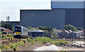
Train approaching Downshire station (June 2014)
The 10.15 Whitehead – Belfast Gt Victoria Street (4011) approaching Downshire station about 2¼ hours before high water Carrickfergus. Kilroot power station http://www.geograph.org.uk/snippet/7765 occupies most of the background. For comparison see Image
Image: © Albert Bridge
Taken: 15 Jun 2014
0.10 miles