IMAGES TAKEN NEAR TO
Sanda Road, NEWTOWNABBEY, BT37 9UD
Introduction
This page details the photographs taken nearby to Sanda Road, BT37 9UD by members of the Geograph project.
The Geograph project started in 2005 with the aim of publishing, organising and preserving representative images for every square kilometre of Great Britain, Ireland and the Isle of Man.

There are currently over 7.5m images from over14,400 individuals and you can help contribute to the project by visiting https://www.geograph.org.uk
Image Map
Images are licensed for reuse under creativecommons.org/licenses/by-sa/2.0
Notes
- Clicking on the map will re-center to the selected point.
- The higher the marker number, the further away the image location is from the centre of the postcode.
Image Listing (18 Images Found)
Images are licensed for reuse under creativecommons.org/licenses/by-sa/2.0
Image
Details
Distance
1

Maxol, Shore Road, Newtownabbey (January 2017)
A pay-at-pump Maxol petrol station, on the Shore Road, near the Longwood Road. Converted from a conventional station and shop.
Image: © Albert Bridge
Taken: 18 Jan 2017
0.09 miles
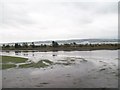
2
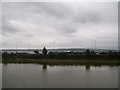
The southern end of the Whitehouse Lagoon
Image: © Eric Jones
Taken: 26 Sep 2013
0.11 miles
3
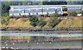
Train, Whitehouse, Newtownabbey - September 2014(1)
A three-car C3K set (3022) passing the Whitehouse lagoon with the 08.55 Larne Harbour – Belfast (Gt Victoria Street).
Image: © Albert Bridge
Taken: 10 Sep 2014
0.12 miles
4
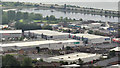
The Longlands Retail Park, Newtownabbey
One of three shopping centres/retail parks, convenient to the M2 at Greencastle, off the Mill Road. Whitehouse lagoon http://www.geograph.org.uk/snippet/4772 and the M5 Image are at the top of the photograph. The view is from the grounds of the Belfast Castle estate.
Image: © Albert Bridge
Taken: 6 Jun 2012
0.13 miles
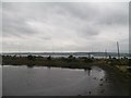
5
Lagoon next to the Shore Road Waste Water Treatment Works
Image: © Eric Jones
Taken: 26 Sep 2013
0.15 miles
6
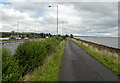
Path, Belfast
The path alongside the M5/M2 motorways in Belfast, part of National Cycle Route 93.
Image: © Rossographer
Taken: 27 Aug 2024
0.16 miles
7
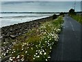
Cycle route to Belfast.
Wildflowers on the National Cycle Network's Route 93 where it runs alongside Belfast Lough. This stretch of the route is part of the Lagan & Lough cycleway, an 18 mile traffic-free route between Whiteabbey and Lisburn.
Image: © Robert Ashby
Taken: 17 Jun 2013
0.17 miles
8
The Shore Road, Newtownabbey
The Shore Road runs from York Road, Belfast to Carrickfergus. The Newtownabbey section runs from Greencastle to Jordanstown Image This is the Whitehouse part passing the shops at Merville Image
Image: © Albert Bridge
Taken: 18 May 2011
0.18 miles
9
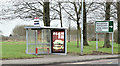
Bus shelter and road sign, Whitehouse, Newtownabbey (January 2017)
Bus shelter and direction sign on the Shore Road, opposite the Longwood Road. The stop is served by inward Metro and Ulsterbus services.
Image: © Albert Bridge
Taken: 18 Jan 2017
0.18 miles