IMAGES TAKEN NEAR TO
Loughshore Manor, NEWTOWNABBEY, BT37 9FD
Introduction
This page details the photographs taken nearby to Loughshore Manor, BT37 9FD by members of the Geograph project.
The Geograph project started in 2005 with the aim of publishing, organising and preserving representative images for every square kilometre of Great Britain, Ireland and the Isle of Man.

There are currently over 7.5m images from over14,400 individuals and you can help contribute to the project by visiting https://www.geograph.org.uk
Image Map
Images are licensed for reuse under creativecommons.org/licenses/by-sa/2.0
Notes
- Clicking on the map will re-center to the selected point.
- The higher the marker number, the further away the image location is from the centre of the postcode.
Image Listing (38 Images Found)
Images are licensed for reuse under creativecommons.org/licenses/by-sa/2.0
Image
Details
Distance
1
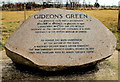
Gideon's Green memorial stone, Whitehouse
Image: © Albert Bridge
Taken: 15 Mar 2010
0.02 miles
2
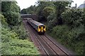
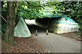
Old Bridge
Train passing under the old bridge at Whitehouse.
Image: © Wilson Adams
Taken: 6 Jun 2008
0.03 miles
3
The Northern End of the M5 Motorway near Whiteabbey
The M5 is a spur motorway, slightly less than 1½ miles in length, in north Belfast. It connects the M2 with the A2 Shore Road at Hazelbank in Newtownabbey. It is a dual two lane road with most of the road on a causeway in Belfast Lough in order to bypass Whitehouse beach.
Image: © David Dixon
Taken: 29 Sep 2017
0.05 miles
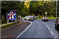
4
The Shore Road, Whiteabbey
The Shore Road at Whiteabbey on the northern fringes of Belfast.
Image: © Rossographer
Taken: 19 Jun 2010
0.07 miles
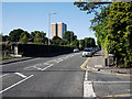
5
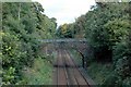
Railway bridge
A railway bridge looking towards Whiteabbey, crossing the Larne Line at Whitehouse.
Image: © Wilson Adams
Taken: 23 Sep 2007
0.09 miles
6

Floral display, Rushpark, Newtownabbey
Image: © Albert Bridge
Taken: 8 Aug 2009
0.10 miles
7
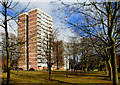
Rushpark flats, Whitehouse
See Image The multi-storey flats at Rushpark date from 1964 (two years after their cousins at Seymour Hill). Once again the setting adds to their architectural quality.
Image: © Albert Bridge
Taken: 15 Mar 2010
0.10 miles
8
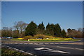
Rushpark roundabout, Whiteabbey
Rushpark roundabout is where the M5 joins the Shore Road, Whiteabbey. The M5 is in the foreground but the “End of Motorway” sign is behind the photographer. The view is towards Carrickfergus.
Image: © Albert Bridge
Taken: 1 Apr 2007
0.10 miles
9
Cycle path near Whiteabbey
Cycle path, from Hazelbank, under the M5 roundabout Image, at Rushpark.
Image: © Albert Bridge
Taken: 8 Aug 2009
0.11 miles
10
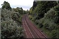
Railway Lines
Railway lines looking towards Belfast.
Image: © Wilson Adams
Taken: 6 Jun 2008
0.11 miles