IMAGES TAKEN NEAR TO
Altmore Green, NEWTOWNABBEY, BT37 9AX
Introduction
This page details the photographs taken nearby to Altmore Green, BT37 9AX by members of the Geograph project.
The Geograph project started in 2005 with the aim of publishing, organising and preserving representative images for every square kilometre of Great Britain, Ireland and the Isle of Man.

There are currently over 7.5m images from over14,400 individuals and you can help contribute to the project by visiting https://www.geograph.org.uk
Image Map
Images are licensed for reuse under creativecommons.org/licenses/by-sa/2.0
Notes
- Clicking on the map will re-center to the selected point.
- The higher the marker number, the further away the image location is from the centre of the postcode.
Image Listing (17 Images Found)
Images are licensed for reuse under creativecommons.org/licenses/by-sa/2.0
Image
Details
Distance
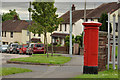
1
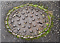
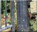
"Browns" manhole cover, Rushpark, Newtownabbey
A manhole cover, from the now-closed Browns foundry, Sydney Street West, Belfast, at The Oaks in the Rushpark estate. The two tower blocks Image date from 1964 which gives a clue to when the cover was cast.
Image: © Albert Bridge
Taken: 13 Nov 2012
0.15 miles
2
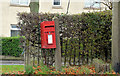
Letter box, Rushpark, Newtownabbey
Post-mounted EIIR box (BT37 766) on the Doagh Road.
Image: © Albert Bridge
Taken: 13 Nov 2012
0.15 miles
3
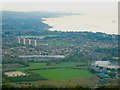
Northern Side of Belfast Lough
Taken from the top of Cave Hill, showing the Northern Shores on Belfast Lough from North Belfast up to Kilroot Power Station.
In the Lough can just be seen the mussel dredger 'Emerald Gratia' http://www.geograph.org.uk/search.php?i=1801055
Image: © Rossographer
Taken: 20 Oct 2007
0.20 miles
4
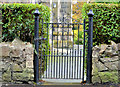
Church gate, Whitehouse, Newtownabbey (1)
The pedestrian gate, on the Whitehouse Park side of the St Mary, Star of the Sea Roman Catholic church on the Shore Road. The church was completed in 1867 to a design by John O’Neill. The spire was added in 1899. The gate post has an inscription showing the name “R J McKinney Belfast” – a business which seems to have traded from 2A Alexandra Park Avenue (Antrim Road) as an iron and smith works in the early part of the 20th century. The gate might be a much later addition. Image shows the inscription.
Image: © Albert Bridge
Taken: 13 Nov 2012
0.20 miles
5
Church gate, Whitehouse, Newtownabbey (2)
See Image The inscription R J McKinney Belfast” on the post on the right in the link.
Image: © Albert Bridge
Taken: 13 Nov 2012
0.20 miles
6
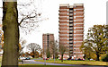
Woodland House and Beechwood House, Rushpark, Newtownabbey
Woodland House Image (background) and Beechwood House, the two blocks forming the Rushpark flats Image, in their setting amidst the landscaping perfected by the old Northern Ireland Housing Trust.
Image: © Albert Bridge
Taken: 13 Nov 2012
0.20 miles
7
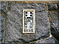
Flush Bracket, Whiteabbey
Flush bracket located on the northern tip of St Mary's Star of the Sea RC Church on the Shore Road, Whiteabbey.
The number on the bracket is OSNIBM 1015.
The mark is 18.40 metres above MSL.
A flush bracket is a type of bench mark set onto the face of a building. See also http://www.geograph.org.uk/search.php?i=11037856 for many other examples I have found.
Image: © Rossographer
Taken: 19 Jun 2010
0.21 miles
8
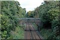
Railway bridge
A railway bridge looking towards Whiteabbey, crossing the Larne Line at Whitehouse.
Image: © Wilson Adams
Taken: 23 Sep 2007
0.22 miles
9
Pillar box, Rathcoole, Newtownabbey
EIIR pillar box (no number visible but it should be BT37 247) at Rathcoole Drive, near Ardfarn Close.
Image: © Albert Bridge
Taken: 9 Jun 2012
0.22 miles
10
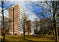
Rushpark flats, Whitehouse
See Image The multi-storey flats at Rushpark date from 1964 (two years after their cousins at Seymour Hill). Once again the setting adds to their architectural quality.
Image: © Albert Bridge
Taken: 15 Mar 2010
0.22 miles