IMAGES TAKEN NEAR TO
Bramble Park, NEWTOWNABBEY, BT37 0XZ
Introduction
This page details the photographs taken nearby to Bramble Park, BT37 0XZ by members of the Geograph project.
The Geograph project started in 2005 with the aim of publishing, organising and preserving representative images for every square kilometre of Great Britain, Ireland and the Isle of Man.

There are currently over 7.5m images from over14,400 individuals and you can help contribute to the project by visiting https://www.geograph.org.uk
Image Map
Images are licensed for reuse under creativecommons.org/licenses/by-sa/2.0
Notes
- Clicking on the map will re-center to the selected point.
- The higher the marker number, the further away the image location is from the centre of the postcode.
Image Listing (7 Images Found)
Images are licensed for reuse under creativecommons.org/licenses/by-sa/2.0
Image
Details
Distance
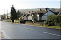
1
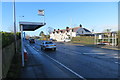
Along the B90
Houses and bus shelters on the B90, also known as the Old Carrick Rd or Upper Road, near Greenisland.
Image: © Robert Ashby
Taken: 20 Jan 2014
0.07 miles
2
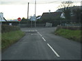
Knockagh Road Junction
The Knockagh Road junction with the Old Carrick Road
Image: © Albert Thompson
Taken: 6 Jan 2009
0.11 miles
3
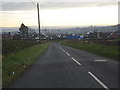
Knockagh Road view
A view from the Koockagh Road facing South towards Belfast. Notice the two large cranes named Samson and Goliath in the Titanic Quarter of Belfast in the background.
Image: © Albert Thompson
Taken: 6 Jan 2009
0.16 miles
4
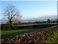
Farmland near the Old Carrick Road
Farmland near the Old Carrick Road looking South East from the Koockagh Road. The Oaklands housing development is beyond the farmland and Belfast Lough can be seen in the distant horizon.
Image: © Albert Thompson
Taken: 13 Jan 2009
0.16 miles
5
Monkstown Road
Neat houses at the north end of the Monkstown Road close to the junction with the B90.
Image: © Robert Ashby
Taken: 20 Jan 2014
0.22 miles
6
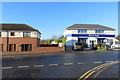
Monkstown Road
Houses and a bank on the Monkstown Road at the junction with Laral Park.
Image: © Robert Ashby
Taken: 20 Jan 2014
0.24 miles
7

Monkstown Road
An unnamed extension of the Monkstown Road. Located on the north side of the B90, also known as the Old Carrick Rd or Upper Road. This short part of the Monkstown Road is a cul-de-sac containing a mix of small businesses and houses.
Image: © Robert Ashby
Taken: 20 Jan 2014
0.24 miles