IMAGES TAKEN NEAR TO
Graymount Crescent, NEWTOWNABBEY, BT36 7DZ
Introduction
This page details the photographs taken nearby to Graymount Crescent, BT36 7DZ by members of the Geograph project.
The Geograph project started in 2005 with the aim of publishing, organising and preserving representative images for every square kilometre of Great Britain, Ireland and the Isle of Man.

There are currently over 7.5m images from over14,400 individuals and you can help contribute to the project by visiting https://www.geograph.org.uk
Image Map
Images are licensed for reuse under creativecommons.org/licenses/by-sa/2.0
Notes
- Clicking on the map will re-center to the selected point.
- The higher the marker number, the further away the image location is from the centre of the postcode.
Image Listing (33 Images Found)
Images are licensed for reuse under creativecommons.org/licenses/by-sa/2.0
Image
Details
Distance
1

Pillar box, Whitewell, Belfast
EIIR pillar box (BT36 341), on the Whitewell Road, close to Whitewell Parade (background).
Image: © Albert Bridge
Taken: 25 Jun 2012
0.10 miles
2

Belfast Trolleybus 214 at the junction of Whitewell Road and Shore Road - 1968
This was the on northern section of the last remaining trolleybus route in Belfast, running across city to Falls Road and would cease operation 4 weeks after my visit.
This view is remarkably little changed, although the cottages whose shadow appears in the foreground have been replace by open space between Shore Road and the motorway, which was not yet built.
The trolleybus is a BUT 9641T with locally built Harkness bodywork, built in 1950.
This is one of a series of views featuring buses in the 60s, 70s, and 80s. http://www.geograph.org.uk/search.php?i=137652761
Image: © Alan Murray-Rust
Taken: 14 Apr 1968
0.11 miles
3

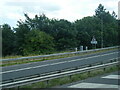
Motorway slip road, Greencastle, Belfast
The northbound off-slip about to join the Shore Road. Used by traffic heading towards the Doagh Road and Whitehouse/Rathcoole.
Image: © Albert Bridge
Taken: 25 May 2012
0.16 miles
4
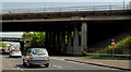
Flyover, Greencastle, Belfast (1)
The M2 (inward and outward lanes) crossing the Shore Road. This off-slip Image is on the right.
Image: © Albert Bridge
Taken: 25 May 2012
0.16 miles
5

Blackberries, Greencastle, Belfast (September 2014)
Blackberries, growing over the crash barrier on the Shore Road, near the M2 outward flyover.
Image: © Albert Bridge
Taken: 19 Sep 2014
0.16 miles
6
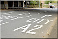
Road markings, Greencastle, Belfast (September 2014)
The buildings of the M2 (north approach road) back in the 1960’s http://www.wesleyjohnston.com/roads/m2.html necessitated the introduction of a one-way system on part of the Shore Road from just north of Gray’s Lane http://www.geograph.org.uk/snippet/11933 to just south of Mount Street. The two lanes on the left are for outward traffic heading towards Whiteabbey and Rathcoole. Second right is the lane for inward traffic via the M2. The lane on the right is for inward traffic along the Shore Road. The inward lanes of the M2 are almost overhead.
Image: © Albert Bridge
Taken: 19 Sep 2014
0.17 miles
7

Newtownabbey boundary sign, Greencastle
The Belfast/Newtownabbey council boundary sign (background in Image) beside the M2 inward flyover on the Shore Road. My understanding of the proposed new boundaries, due in 2015, is that this one is unchanged, here, but Newtownabbey will become part of a bigger Antrim and Newtownabbey district.
Image: © Albert Bridge
Taken: 19 Sep 2014
0.17 miles
8
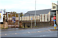
Former Greencastle police station, Belfast (2)
See Image (February 2013). The building has now been demolished. The Planning Service website discloses that planning permission was given on 28 March 2013 for Z/2011/0537/O “Demolition of redundant Police Station and erection of 2 no Business/retail units and 23 no 2 bedroom apartments and parking (Amended scheme)”.
Image: © Albert Bridge
Taken: 11 Nov 2013
0.18 miles
9
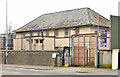
Former Greencastle police station, Belfast
The former Greencastle police station on the Shore Road which, despite the alterations, has the appearance of being a TFO Rippingham design. There is now an application for planning permission (2 November 2012): “0537/O 804 Shore Road Greencastle Demolition of redundant Police Station and erection of 2 no Business/retail units and 23 no 2 bedroom apartments and parking (Amended scheme)”. At the date of submission the Planning Service website shows “APPLICATION DEFERRED FOR FURTHER CONSIDERATION”. This photograph appears as a matter of geographical and historical record only. It does nor express any opinion for or against the application. Image shows a post-demolition view in November 2013.
Image: © Albert Bridge
Taken: 22 Feb 2013
0.18 miles