IMAGES TAKEN NEAR TO
Roughfort Road, NEWTOWNABBEY, BT36 4RB
Introduction
This page details the photographs taken nearby to Roughfort Road, BT36 4RB by members of the Geograph project.
The Geograph project started in 2005 with the aim of publishing, organising and preserving representative images for every square kilometre of Great Britain, Ireland and the Isle of Man.

There are currently over 7.5m images from over14,400 individuals and you can help contribute to the project by visiting https://www.geograph.org.uk
Image Map
Images are licensed for reuse under creativecommons.org/licenses/by-sa/2.0
Notes
- Clicking on the map will re-center to the selected point.
- The higher the marker number, the further away the image location is from the centre of the postcode.
Image Listing (6 Images Found)
Images are licensed for reuse under creativecommons.org/licenses/by-sa/2.0
Image
Details
Distance
1
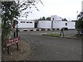
Belfast Royal Academy
It is located along the Roughfort Road
Image: © Kenneth Allen
Taken: 14 Oct 2009
0.08 miles
2
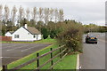
Roughfort Road
Cottage on the Roughfort Road near Mallusk.
Image: © Robert Ashby
Taken: 23 Oct 2014
0.11 miles
3
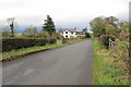
Craigarogan Road
A short road running between Roughfort Road and Old Coach Road near Mallusk.
Image: © Robert Ashby
Taken: 23 Oct 2014
0.17 miles
4
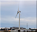
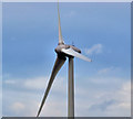
Wind turbine, Mallusk, Newtownabbey (1)
A wind turbine, commissioned in 2011, at commercial premises at Mallusk. The owner’s website includes the following information “Preparatory site work began in September 2010 towards a scheduled completed commissioning date of early June 2011 . . . . The Enercon E-70 wind turbine has a blade span of 71 metres and when the blade is fully extended the structure measures 99.5 metres from the ground to the blade tip. With an output of 2.3mwatt the wind turbine will contribute 20% of [the owner’s] energy needs. Having supplied and installed the wind turbine Enercon have also been contracted for its ongoing maintenance”. Image shows a close view of the blades.
This photograph appears as a matter of neutral record only and should not be interpreted as expressing any opinion, for or against, the turbine.
Image: © Albert Bridge
Taken: 25 Jan 2012
0.21 miles
5
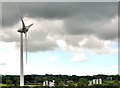
Wind turbine, Mallusk, Newtownabbey (2)
See Image A closer look at the blades turning in a stiff breeze. The old one-inch map shows a nearby spot height of 387 ft. The surrounding area is flat. This photograph appears as a matter of neutral record only and should not be interpreted as expressing any opinion, for or against, the turbine.
Image shows the view from the Roughfort Road.
Image: © Albert Bridge
Taken: 25 Jan 2012
0.21 miles
6
Wind turbine, Mallusk, Newtownabbey (3)
See Image The same turbine seen from the Roughfort Road. This photograph appears as a matter of neutral record only and should not be interpreted as expressing any opinion, for or against, the turbine.
Image: © Albert Bridge
Taken: 24 Jun 2012
0.21 miles