IMAGES TAKEN NEAR TO
Duburren Road, NEWRY, BT35 9UT
Introduction
This page details the photographs taken nearby to Duburren Road, BT35 9UT by members of the Geograph project.
The Geograph project started in 2005 with the aim of publishing, organising and preserving representative images for every square kilometre of Great Britain, Ireland and the Isle of Man.

There are currently over 7.5m images from over14,400 individuals and you can help contribute to the project by visiting https://www.geograph.org.uk
Image Map
Images are licensed for reuse under creativecommons.org/licenses/by-sa/2.0
Notes
- Clicking on the map will re-center to the selected point.
- The higher the marker number, the further away the image location is from the centre of the postcode.
Image Listing (10 Images Found)
Images are licensed for reuse under creativecommons.org/licenses/by-sa/2.0
Image
Details
Distance
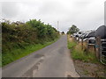
1
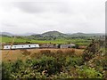
Derelict farmhouse south of the Duburren Road
The hills in the middle ground are part of the northern quadrant of the Ring of Gullion. While their steep eastern facing slopes are uncultivated, their gentler western slopes, with the exception of the rocky summits have been reclaimed and support good crops of cultivated grass for the areas dairy economy.
Image: © Eric Jones
Taken: 20 Aug 2019
0.00 miles
2
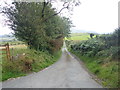
The North-western end of Courtney Roads
The image was taken from the junction with the Duburren Road.
Image: © Eric Jones
Taken: 20 Aug 2019
0.07 miles
3
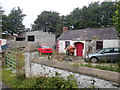
Traditional cottage on the Duburren Road
This former farmstead cottage stands opposite the junction with the equally narrow Courtney Road.
Image: © Eric Jones
Taken: 20 Aug 2019
0.09 miles
4
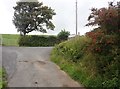
The western end of Duburren Road
Here, Duburren Road joins the north-south Barr Road.
Image: © Eric Jones
Taken: 20 Aug 2019
0.13 miles
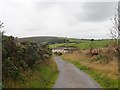
5
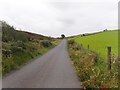
View North along Barr Road
This image was taken from the junction of the Duburren and Barr roads.
Image: © Eric Jones
Taken: 20 Aug 2019
0.14 miles
6
Farmhouse and outbuildings on the Barr Road
The image was taken from the Duburren Road. The wind turbine in the background is in Annaclough Hill.
Image: © Eric Jones
Taken: 20 Aug 2019
0.14 miles
7
View South on the Barr Road towards the junction with Duburren Road junction
Image: © Eric Jones
Taken: 20 Aug 2019
0.15 miles
8
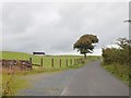
Sycamore tree on the Barr Road
This stands on the edge of reclaimed mountain land which now produces rich silage crops.
Image: © Eric Jones
Taken: 20 Aug 2019
0.22 miles
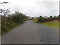
9
The Barr Road running south-west between wildscape and cultivated grassland
The steeper land on the east side of the road is un-reclaimed heathland - the gentler land on the west side has been reclaimed in recent years and produces excellent crops of cultivated grassland.
Image: © Eric Jones
Taken: 20 Aug 2019
0.23 miles
10
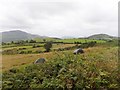
Parts of the Northern and Western Quadrants of the Ring of Gullion
Much of the land on the more gentle sloping slopes of the northern quadrant of the Ring have been reclaimed and planted with cultivated grasses and supports a pastoral economy. These slopes are in marked contrast to the scarps facing Slieve Gullion (background left) which are covered mainly in heath and scrub vegetation. The hill on the right in the Ring of Gullion is part of the Slievenacappel group of uplands.
Image: © Eric Jones
Taken: 20 Aug 2019
0.24 miles