IMAGES TAKEN NEAR TO
Slieve View, NEWRY, BT35 9PN
Introduction
This page details the photographs taken nearby to Slieve View, BT35 9PN by members of the Geograph project.
The Geograph project started in 2005 with the aim of publishing, organising and preserving representative images for every square kilometre of Great Britain, Ireland and the Isle of Man.

There are currently over 7.5m images from over14,400 individuals and you can help contribute to the project by visiting https://www.geograph.org.uk
Image Map
Images are licensed for reuse under creativecommons.org/licenses/by-sa/2.0
Notes
- Clicking on the map will re-center to the selected point.
- The higher the marker number, the further away the image location is from the centre of the postcode.
Image Listing (11 Images Found)
Images are licensed for reuse under creativecommons.org/licenses/by-sa/2.0
Image
Details
Distance
1
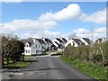
New housing estate at Tullydonnell
Tullydonnell is a commuting village with residents employed both north and south of the border.
Image: © Eric Jones
Taken: 30 Apr 2013
0.02 miles
2
Oliver Plunkett Park, Tullydonnell
Tullydonnell is a commuting village with residents employed both north and south of the border.
Image: © Eric Jones
Taken: 30 Apr 2013
0.06 miles
3
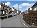
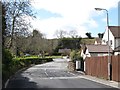
Approaching the village of Tullydonnell from the east along Tullydonnell Road
Image: © Eric Jones
Taken: 30 Apr 2013
0.07 miles
4
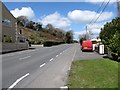
The A29 (Portrush) road at Tullydonnell O'Callaghan
This section of the A29 is also known as New Road.
Image: © Eric Jones
Taken: 30 Apr 2013
0.08 miles
5
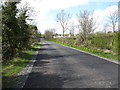
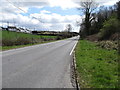
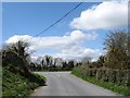
The Tullydonnell Road approaching the junction with the A29 at Tullydonnell
A short distance down the road, the A29 crosses into Co Louth and becomes the R177 (Dundalk) Road.
Image: © Eric Jones
Taken: 30 Apr 2013
0.08 miles
6
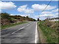
View south-eastwards along the A29 (New Road) at Tullydonnell
Image: © Eric Jones
Taken: 30 Apr 2013
0.10 miles
7
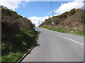
The A29 heading north-westwards from the South Armagh village of Tullydonnell
The A29 crosses the whole of Northern Ireland from Drumbilla on the Armagh-Louth border, some 2km SE of Tullydonnell, to Portrush near the Giant's Causeway. At the Border it joins the R177.
Image: © Eric Jones
Taken: 30 Apr 2013
0.13 miles
8
Road linking the A29 and Ballsmill Road at Tullydonnell
Image: © Eric Jones
Taken: 30 Apr 2013
0.19 miles
9
The unnamed link road from the A29 at its junction with Ballsmill Road
Image: © Eric Jones
Taken: 30 Apr 2013
0.23 miles
10
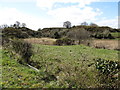
Disused quarry working alongside Ballsmill Road
Image: © Eric Jones
Taken: 30 Apr 2013
0.23 miles