IMAGES TAKEN NEAR TO
Ballynamadda Road, NEWRY, BT35 8TD
Introduction
This page details the photographs taken nearby to Ballynamadda Road, BT35 8TD by members of the Geograph project.
The Geograph project started in 2005 with the aim of publishing, organising and preserving representative images for every square kilometre of Great Britain, Ireland and the Isle of Man.

There are currently over 7.5m images from over14,400 individuals and you can help contribute to the project by visiting https://www.geograph.org.uk
Image Map
Images are licensed for reuse under creativecommons.org/licenses/by-sa/2.0
Notes
- Clicking on the map will re-center to the selected point.
- The higher the marker number, the further away the image location is from the centre of the postcode.
Image Listing (58 Images Found)
Images are licensed for reuse under creativecommons.org/licenses/by-sa/2.0
Image
Details
Distance
1
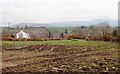
Development land at the north end of Ballynamadda Road
This is located in the centre of the village of Drumintee.
Image: © Eric Jones
Taken: 9 Apr 2018
0.01 miles
2
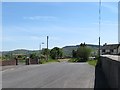
The northern end of Ballynamadda Road
The junction with Finegans Road can be seen in the middle distance.
Image: © Eric Jones
Taken: 9 Apr 2018
0.01 miles
3
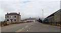
Houses at the northern end of Ballynamadda Road, Drumintee
Image: © Eric Jones
Taken: 9 Apr 2018
0.01 miles
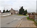
4
The junction of Ballynamadda Road and Finegans Road at Drumintee
Image: © Eric Jones
Taken: 16 May 2013
0.03 miles
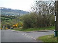
5
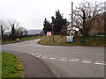
Staggered crossroads by Drumintee Chapel
The image was taken from the New Line Road. The road going across is Finegans Road which links the B113 with the village of Jonesborough. The road going south is Ballynamadda Road.
Image: © Eric Jones
Taken: 9 Apr 2018
0.04 miles
6
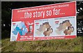
Republican poster attacking the proposed revisions of NI Assembly Election Boundaries
The gist of the message conveyed by this Nationalist poster is that the constituency boundary proposals of the Election Commission for Northern Ireland are too much akin to those proposed by the Democratic Unionist Party. The face of Iain Paisley jnr is not one encountered very often in Nationalist and Republican South Armagh.
Image: © Eric Jones
Taken: 9 Apr 2018
0.04 miles
7
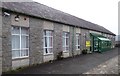
Scouting Ireland "den" in the village of Drumintee
This is the meeting place of the 12th Armagh "Slieve Gullion" group.
Image: © Eric Jones
Taken: 9 Apr 2018
0.04 miles
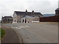
8
HQ of 12th Armagh "Slieve Gullion" Scouts
This is a branch of the Irish Scouting movement. Scouting Ireland has 50,000 members across the island of Ireland including Northern Ireland, where it works in tandem with the Scout Association in Northern Ireland (SANI), which is part of The Scout Association in the United Kingdom. The "den" has the appearance of being a former village school building.
Image: © Eric Jones
Taken: 9 Apr 2018
0.04 miles
9
Crossroads near the chapel at Drumintee
Here the New Line and Ballynamadda Road cross the busy Finegan Road which leads to Jonesborough.
Image: © Eric Jones
Taken: 7 Jun 2013
0.04 miles
10
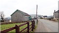
The upper end of Ballynamadda Road, Dromintee
The village is variously known as Dromintee and Drumintee and in Irish Druim an Tighe, and Droim an Tí. Such variations are common in Ireland. The name means "Ridge of the House". Its Welsh equivalent would be Drum y Ty.
Image: © Eric Jones
Taken: 9 Apr 2018
0.04 miles