IMAGES TAKEN NEAR TO
Green Road, NEWRY, BT35 8SD
Introduction
This page details the photographs taken nearby to Green Road, BT35 8SD by members of the Geograph project.
The Geograph project started in 2005 with the aim of publishing, organising and preserving representative images for every square kilometre of Great Britain, Ireland and the Isle of Man.

There are currently over 7.5m images from over14,400 individuals and you can help contribute to the project by visiting https://www.geograph.org.uk
Image Map
Images are licensed for reuse under creativecommons.org/licenses/by-sa/2.0
Notes
- Clicking on the map will re-center to the selected point.
- The higher the marker number, the further away the image location is from the centre of the postcode.
Image Listing (8 Images Found)
Images are licensed for reuse under creativecommons.org/licenses/by-sa/2.0
Image
Details
Distance
1
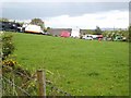
Informal transport yard on Carn Hill
This field on Carn Hill seems to serve both as car breakers, and a transport yard principally for horse transporters.
Image: © Oliver Dixon
Taken: 13 May 2007
0.15 miles
2
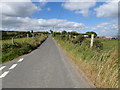
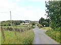
The northern section of Carn Road
This section links with Seavers Road.
Image: © Eric Jones
Taken: 21 Jun 2018
0.15 miles
3
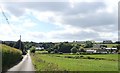
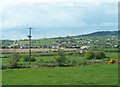
Settlement on the north side of the Ayallogue Cross Roads
These are located on the eastern side of Carn Hill.
Image: © Eric Jones
Taken: 21 Jun 2018
0.18 miles
4
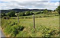
View across pasture land towards Camlough Mountain
The three communications masts on its summit ridge make Camlough Mountain easily identifiable.
Image: © Eric Jones
Taken: 21 Jun 2018
0.18 miles
5
Unnamed road linking Carn Road and Seafin Road
The uplands in the middle distance across the Flurry River Valley are Slieve Gullion and Camlough Mountain. Beyond the col are the familiar outline of Sugarloaf Hill and Sturgan Mountain.
Image: © Eric Jones
Taken: 21 Jun 2018
0.21 miles
6
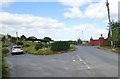
Ribbon development along Ayallogue Road
This image was taken from the B113 at a point between Meigh and Cloghoge, Carn Hill forms the background.
Image: © Eric Jones
Taken: 16 May 2013
0.22 miles
7
The bifurcation of Carn Road on Carn Hill
The road on the right leads to Cloghoge.
Image: © Eric Jones
Taken: 21 Jun 2018
0.23 miles
8
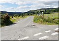
The Ayallogue Cross Roads on the Carn Road
The camera points east in the direction of the suburban village of Cloghoge.
Image: © Eric Jones
Taken: 21 Jun 2018
0.24 miles