IMAGES TAKEN NEAR TO
Finegans Road, NEWRY, BT35 8JB
Introduction
This page details the photographs taken nearby to Finegans Road, BT35 8JB by members of the Geograph project.
The Geograph project started in 2005 with the aim of publishing, organising and preserving representative images for every square kilometre of Great Britain, Ireland and the Isle of Man.

There are currently over 7.5m images from over14,400 individuals and you can help contribute to the project by visiting https://www.geograph.org.uk
Image Map
Images are licensed for reuse under creativecommons.org/licenses/by-sa/2.0
Notes
- Clicking on the map will re-center to the selected point.
- The higher the marker number, the further away the image location is from the centre of the postcode.
Image Listing (12 Images Found)
Images are licensed for reuse under creativecommons.org/licenses/by-sa/2.0
Image
Details
Distance
1
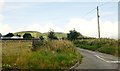
The Molly Road Lower junction with Finegans Road
Faughall Mountain forms the background.
Image: © Eric Jones
Taken: 2 Aug 2019
0.17 miles
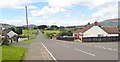
2
Molly Road Lower approaching its junction with Finegans Road
The junction is located on the west side of Jonesborough. Dundalk Bay can be seen in the background.
Image: © Eric Jones
Taken: 9 Aug 2018
0.17 miles
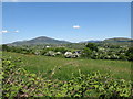
3
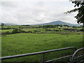
View northwestwards across farmland from the Kilnasaggart Road
This is an area of pastoral farming. The upland in the background is Slieve Gullion.
Image: © Eric Jones
Taken: 20 Jun 2012
0.17 miles
4
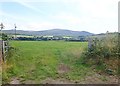
Grassland east of Faughillotra Road
This is part of the Plain of Meigh which extends north and west of the village of Jonesborough. Beyond the village is the south-eastern quadrant of the Ring of Gullion, including Clermont Carn (with the aerials on its summit) and on the right, in the middle ground, Feede Mountain.
Image: © Eric Jones
Taken: 2 Aug 2019
0.18 miles
6
View West along Finegan's Road, Jonesborough
The volcanic hills of South Armagh provide the background. These are the south western section of the Ring of Gullion. Slieve Gullion itself stands on the extreme right of the image.
Image: © Eric Jones
Taken: 9 Aug 2018
0.23 miles
7
The Gap of the North from Moyry Castle
Road and railway routes between Leinster and Ulster are channelled through the Gap and since time immemorial the Gap has been the scene of many battles. It has been pivotal in both history and folklore; it was here that Cúchulainn defended Ulaidh from the forces of Connacht and it remained under the control of the Irish until the 1600s when Mountjoy built his castle at Moyry. The hills of the Ring of Gullion provides the background.
Image: © Eric Jones
Taken: 7 Jun 2013
0.23 miles
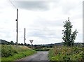
8
Finegans Road exiting Jonesborough
The camera points westwards in the direction of Dromintee.
Image: © Eric Jones
Taken: 9 Aug 2018
0.24 miles
9
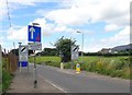
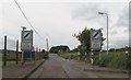
Traffic controlling measures on Finegans Road, Jonesborough
Image: © Eric Jones
Taken: 9 Aug 2018
0.24 miles
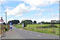
10
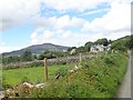
Pasture land west of Molly Road Lower
The large hill in the background is Slieve Gullion.
Image: © Eric Jones
Taken: 9 Aug 2018
0.24 miles