IMAGES TAKEN NEAR TO
Kilnasaggart Road, NEWRY, BT35 8JA
Introduction
This page details the photographs taken nearby to Kilnasaggart Road, BT35 8JA by members of the Geograph project.
The Geograph project started in 2005 with the aim of publishing, organising and preserving representative images for every square kilometre of Great Britain, Ireland and the Isle of Man.

There are currently over 7.5m images from over14,400 individuals and you can help contribute to the project by visiting https://www.geograph.org.uk
Image Map
Images are licensed for reuse under creativecommons.org/licenses/by-sa/2.0
Notes
- Clicking on the map will re-center to the selected point.
- The higher the marker number, the further away the image location is from the centre of the postcode.
Image Listing (92 Images Found)
Images are licensed for reuse under creativecommons.org/licenses/by-sa/2.0
Image
Details
Distance
1
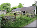
Disused farmstead on the Kilnasaggart Road
Image: © Eric Jones
Taken: 20 Jun 2012
0.02 miles

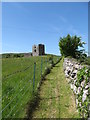
3
Fenced path linking Moyry Castle and the Kilnasaggart Road
Image: © Eric Jones
Taken: 2 Aug 2019
0.03 miles
4
Well cared for access path to Moyry Castle
This path links the fortress with the Kilnasaggart Road.
Image: © Eric Jones
Taken: 7 Jun 2013
0.04 miles
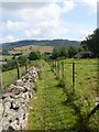
5
A shelter belt of trees to the side of the Moyry Castle site
Image: © Eric Jones
Taken: 2 Aug 2019
0.05 miles
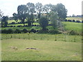
6
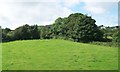
Pastureland below Slievebolea
Moiry Castle can be seen on the extreme left of the image.
Image: © Eric Jones
Taken: 22 Aug 2009
0.06 miles
7
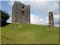
The tower of Moyry Castle and a surviving section of the bawn wall
https://apps.communities-ni.gov.uk/nismr-public/docs/ARM/ARM_032/ARM_032_005/Public/SM7-ARM-032-005-002.pdf
Image: © Eric Jones
Taken: 2 Aug 2019
0.06 miles
8
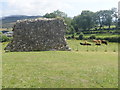
Surviving section of the bawn wall of Moyry Castle
https://apps.communities-ni.gov.uk/nismr-public/docs/ARM/ARM_032/ARM_032_005/Public/SM7-ARM-032-005-002.pdf
Image: © Eric Jones
Taken: 2 Aug 2019
0.06 miles
9
Ascending the Department for Communities path to Moyry Castle
This early 17thC tower house is a scheduled monument maintained by the Department for Communities. The site contains a three storey tower house and a fragment of a bawn (courtyard) wall.
https://apps.communities-ni.gov.uk/nismr-public/docs/ARM/ARM_032/ARM_032_005/Public/SM7-ARM-032-005-002.pdf
Image: © Eric Jones
Taken: 2 Aug 2019
0.06 miles
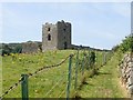
10
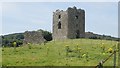
Moyry Castle on the slopes of Slievenabolea
The castle consists of a tower house and the fragment of a courtyard wall.
https://apps.communities-ni.gov.uk/nismr-public/docs/ARM/ARM_032/ARM_032_005/Public/SM7-ARM-032-005-002.pdf
Image: © Eric Jones
Taken: 2 Aug 2019
0.07 miles