IMAGES TAKEN NEAR TO
Ashtree Hill, NEWRY, BT35 6TR
Introduction
This page details the photographs taken nearby to Ashtree Hill, BT35 6TR by members of the Geograph project.
The Geograph project started in 2005 with the aim of publishing, organising and preserving representative images for every square kilometre of Great Britain, Ireland and the Isle of Man.

There are currently over 7.5m images from over14,400 individuals and you can help contribute to the project by visiting https://www.geograph.org.uk
Image Map
Images are licensed for reuse under creativecommons.org/licenses/by-sa/2.0
Notes
- Clicking on the map will re-center to the selected point.
- The higher the marker number, the further away the image location is from the centre of the postcode.
Image Listing (18 Images Found)
Images are licensed for reuse under creativecommons.org/licenses/by-sa/2.0
Image
Details
Distance
1
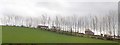
Shelter belt on the slopes of Ashtree Hill
The image was taken from the A27.
Image: © Eric Jones
Taken: 21 Feb 2019
0.05 miles
2
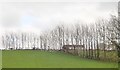
Shelter belt on drumlin slope above the A27 (Tandragee Road)
Image: © Eric Jones
Taken: 21 Feb 2019
0.05 miles
3
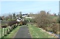
Houses on a drumlin north of Jerrettspass
These houses, here photographed from the towpath of the Newry Canal, are located between the railway and the summit Ashtree Hill.
Image: © Eric Jones
Taken: 21 Feb 2019
0.08 miles
4
Newry Canal
Entrance to Canal Wood, a nature reserve beside the canal maintained by the Woodland Trust.
Image: © Robert Ashby
Taken: 29 Oct 2014
0.16 miles
5
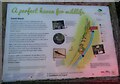
Canal Wood information board at northern entrance to the woodland
The Woodland Trust Canal Wood information board at the northern entrance.
Image: © P Webb
Taken: 2 Apr 2021
0.18 miles
6
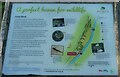
Canal Wood information board at the southern entrance.
The Woodland Trust Canal Wood information board at the southern entrance.
Image: © P Webb
Taken: 2 Apr 2021
0.18 miles
7
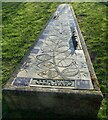
Canal Wood sculpture
A sculpture at The Woodland Trust Canal Wood. This sculpture reflects the fact that the woodland lies between to Belfast to Newry railway line and the disused Newry to Portadown canal.
Image: © P Webb
Taken: 2 Apr 2021
0.18 miles
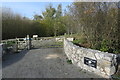
8
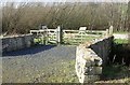
Southern entrance to the Woodland Trusts Canal Wood round path
The carved seat inside the gate is the work of the Northern Irish artist Eleanor Wheeler
https://www.guidigo.com/Web/Newry-Canal-Towpath-Tour/UceboJcGknw/Stop/17/Canal-Wood-South-Entrance
Image: © Eric Jones
Taken: 21 Feb 2019
0.19 miles
9
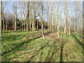
The Woodland Trust's Canal Wood
The land between the railway and the canal towpath was purchased from the Northern Ireland Transport Holdings by the Woodland Trust in 2000. Since then 2.7 hectares of the site has been planted with over 6000 trees to create a community woodland. These trees are a mix of alder, willow and other broadleaves. Approximately 2.5 ha of the site is being kept as open wetland.
Image: © Eric Jones
Taken: 21 Feb 2019
0.20 miles
10
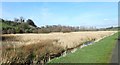
View NNW across wetland to Canal Wood
The image was taken from the towpath of the Newry Canal.
Image: © Eric Jones
Taken: 21 Feb 2019
0.21 miles