IMAGES TAKEN NEAR TO
Canal Bank, NEWRY, BT35 6SP
Introduction
This page details the photographs taken nearby to Canal Bank, BT35 6SP by members of the Geograph project.
The Geograph project started in 2005 with the aim of publishing, organising and preserving representative images for every square kilometre of Great Britain, Ireland and the Isle of Man.

There are currently over 7.5m images from over14,400 individuals and you can help contribute to the project by visiting https://www.geograph.org.uk
Image Map
Images are licensed for reuse under creativecommons.org/licenses/by-sa/2.0
Notes
- Clicking on the map will re-center to the selected point.
- The higher the marker number, the further away the image location is from the centre of the postcode.
Image Listing (8 Images Found)
Images are licensed for reuse under creativecommons.org/licenses/by-sa/2.0
Image
Details
Distance
1
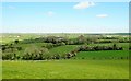
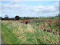
Undulating landscape of the Armagh/Down borderland
The image was taken from the Old Road in the direction of the Newry Canal which broadly marks the county line.
Image: © Eric Jones
Taken: 10 Apr 2019
0.08 miles
2
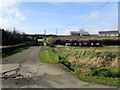
Private farm access road from the Canal Bank
This road accesses two farms.
Image: © Eric Jones
Taken: 21 Feb 2019
0.09 miles
3
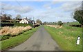
New bungalow on the Canal Bank
This bungalow overlooking the Newry Canal is located about 0.5 miles South of the village of Poyntzpass.
Image: © Eric Jones
Taken: 21 Feb 2019
0.15 miles
4
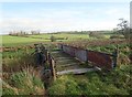
A timber and iron sheeting bridge between Locks 10 and 9
The image was taken from the Canal Bank road.
Image: © Eric Jones
Taken: 21 Feb 2019
0.16 miles
5
View North towards the farm bridge linking farmland east of the Newry Canal with the Canal Bank lane
Image: © Eric Jones
Taken: 21 Feb 2019
0.16 miles
6
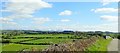
View SSE across the South Co Down drumlin country
The Mourne Mountain feature in the background. The image was taken from the Old Road.
Image: © Eric Jones
Taken: 10 Apr 2019
0.22 miles
7
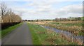
View NNW along Canal Bank in the direction of Poyntzpass
The land on the east side of the canal is wetland. The Newry Canal between Poyntzpass and Jerrettspass was constructed through riverine marshes. The two villages developed at locations where the wetland could be crossed, such locations being known as 'passes'.
Image: © Eric Jones
Taken: 21 Feb 2019
0.22 miles
8
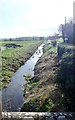
The abandoned Newry Canal South of The McVeigh Lock (Lock 10)
Image: © Eric Jones
Taken: 21 Feb 2019
0.24 miles