IMAGES TAKEN NEAR TO
Carnbane Road, NEWRY, BT35 6QA
Introduction
This page details the photographs taken nearby to Carnbane Road, BT35 6QA by members of the Geograph project.
The Geograph project started in 2005 with the aim of publishing, organising and preserving representative images for every square kilometre of Great Britain, Ireland and the Isle of Man.

There are currently over 7.5m images from over14,400 individuals and you can help contribute to the project by visiting https://www.geograph.org.uk
Image Map
Images are licensed for reuse under creativecommons.org/licenses/by-sa/2.0
Notes
- Clicking on the map will re-center to the selected point.
- The higher the marker number, the further away the image location is from the centre of the postcode.
Image Listing (22 Images Found)
Images are licensed for reuse under creativecommons.org/licenses/by-sa/2.0
Image
Details
Distance
1
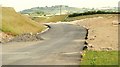
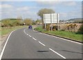
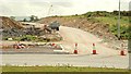
The new Newry bypass (63)
Image: © Albert Bridge
Taken: 13 Jun 2009
0.06 miles
2
The new Newry bypass (90)
See Image The new bypass, between the Tanderagee Road flyover Image (out of picture to the left) and the Carnbane junction (top right). See Image
Image: © Albert Bridge
Taken: 23 Oct 2009
0.06 miles
3
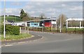
Newry Youth Resource Centre
This is located at the Carnbane Roundabout.
Image: © Eric Jones
Taken: 10 Apr 2019
0.06 miles
4
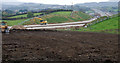
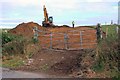
The new Newry bypass (36)
See Image The slip road, to the Carnbane junction, seen from the canal towpath near Shepherds Way Image The heap of soil marks the new roundabout on the (hidden) Tanderagee Road. Continue to Image
Image: © Albert Bridge
Taken: 4 Apr 2009
0.06 miles
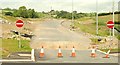
5
Just about to leave the Newry 40mph speed restriction zone on the A27
The large sign on the right shows the layout of the up-coming Carnbane Roundabout
Image: © Eric Jones
Taken: 10 Apr 2019
0.07 miles
6
The new Newry bypass (61)
See Image The site for the southbound off-slip at Carnbane – complete with “no entry” signs. Continue to Image
Image: © Albert Bridge
Taken: 13 Jun 2009
0.08 miles
7
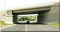
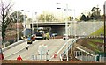
The new Newry bypass (59)
See Image The Tanderagee and Armagh Roads will be served by a grade-separated junction at Carnbane, close to the Tanderagee Road. The Carnbane Road Image has been rebuilt, on a new line, between this new flyover and the Tanderagee Road (background). The flyover is approximately on the site of the closed (1965) GNR(I) line from Goraghwood to Newry and Warrenpoint. Continue to Image
Image: © Albert Bridge
Taken: 13 Jun 2009
0.09 miles
8
The new Newry bypass (62)
Image: © Albert Bridge
Taken: 13 Jun 2009
0.10 miles
9
The new Newry bypass (64)
Image: © Albert Bridge
Taken: 13 Jun 2009
0.11 miles
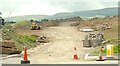
10
The new Newry bypass (2)
See Image The link road on the other side of the Carnbane Road (looking towards the Tanderagee Road). Continue to Image
Image: © Albert Bridge
Taken: 2 Nov 2007
0.11 miles