IMAGES TAKEN NEAR TO
Caulfield Place, NEWRY, BT35 6AS
Introduction
This page details the photographs taken nearby to Caulfield Place, BT35 6AS by members of the Geograph project.
The Geograph project started in 2005 with the aim of publishing, organising and preserving representative images for every square kilometre of Great Britain, Ireland and the Isle of Man.

There are currently over 7.5m images from over14,400 individuals and you can help contribute to the project by visiting https://www.geograph.org.uk
Image Map
Images are licensed for reuse under creativecommons.org/licenses/by-sa/2.0
Notes
- Clicking on the map will re-center to the selected point.
- The higher the marker number, the further away the image location is from the centre of the postcode.
Image Listing (336 Images Found)
Images are licensed for reuse under creativecommons.org/licenses/by-sa/2.0
Image
Details
Distance
1
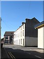
Mixed usage in Caulfield Place in Newry's Zone of Transition
Some of the houses are inhabited, some are disused and boarded up. Others have been converted into office buildings. New buildings have also been added as part of the transition process.
Image: © Eric Jones
Taken: 7 Jun 2013
0.00 miles
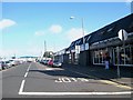
2
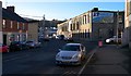
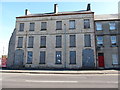
Edward Street, Newry
Edward Street in Newry.
Image: © Rossographer
Taken: 4 Dec 2013
0.02 miles
3
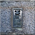
Flush Bracket, Newry
Flush bracket bench mark located on the south eastern tip of a former warehouse (now a carpet shop) on Edward Street in Newry Image
The number on the bracket is OSNIBM 3190.
The mark is 4.19 metres above MSL.
From memory this is the last bracket in the primary line from Belfast to Newry (via Dundonald, Comber and Downpatrick) that began at Image
Image: © Rossographer
Taken: 4 Dec 2013
0.03 miles
4
JT Carpet Warehouse in Upper Edward Street, Newry
Image: © Eric Jones
Taken: 7 Jun 2013
0.03 miles
5
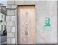
"We defy you! Do your worst!" an ?ir?g? Graffiti in Edward Street
The quotation comes from an article in the "Irish Worker" in 1914 and was addressed to the British administration in Ireland by the author the Scottish-born Irish republican and socialist leader, James Connolly, pictured in the graffiti. Éirígí (meaning "arise") is a republican socialist party active north and south of the border. http://en.wikipedia.org/wiki/%C3%89ir%C3%ADg%C3%AD
Image: © Eric Jones
Taken: 16 May 2012
0.03 miles
6
Derelict property in Newry's Zone of Transition
These boarded-up houses are in Corry Square, Edward Street. The site of the demolished building to the left of these houses is used as an Auto-Wash Lot. Such usage is common in Zones of Transition
Image: © Eric Jones
Taken: 7 Jun 2013
0.03 miles
7
McClelland Park. Edward Street, Newry
This park is used as a venue for outdoor concerts. It was previously the site of the Cory Square RUC Barracks. The station was mortared by the IRA in February 1985 resulting in the death of nine officers and the injuring of many more.
http://www.newry.ie/news/latest-news/3164-30th-anniversary-of-corry-square-mortar-attack
Image: © Eric Jones
Taken: 7 Jun 2013
0.04 miles
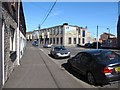
9
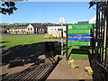
Shops in Railway Avenue, Newry
This Railway Avenue was named after a defunct branch line serving the port of Newry. The bus depot in the background occupies former railway land.
Image: © Eric Jones
Taken: 22 Aug 2009
0.05 miles
10
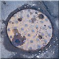
Manhole Cover, Newry
A type no.9 "Lockanlift" from the foundry of A.C. Bamlett Ltd. of Thirsk. This is located in Edward Street, Newry Image The foundry, founded c1864, closed in 1980. The "Lockanlift" also appears to have been manufactured elsewhere such as http://www.flickr.com/photos/sgwarnog/6893584684/ .
Image: © Rossographer
Taken: 4 Dec 2013
0.05 miles