1
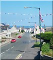
Main Street, Annalong
This links the A2 with the harbour.
Image: © Eric Jones
Taken: 22 Sep 2015
0.03 miles
2
Main Street, Annalong
The red, white and blue painted kerb stones is a remainder that Annalong is in ethos a predominantly Loyalist village. The 2011 Census recorded that 52.69% of the population belonged to or were brought up in a Protestant religion compared with 43% in the Catholic religion.
Image: © Eric Jones
Taken: 16 Oct 2019
0.03 miles
3
The northern end of Main Street, Annalong
In the background, on the A2, is Annalong Presbyterian Church.
Image: © Eric Jones
Taken: 30 Apr 2011
0.03 miles
4
Main Street, Annalong
Main Street leads from the A2 down towards the harbour. The flags and bunting are characteristic of the Loyalist areas of Northern Ireland in the days approaching the Twelfth of July.
http://cain.ulst.ac.uk/images/symbols/flags.htm
Image: © Eric Jones
Taken: 1 Jul 2014
0.03 miles
5
Victorian houses in the centre of Annalong
Image: © Eric Jones
Taken: 16 Mar 2011
0.03 miles
6
Approaching the Orange Arch in Glasdrumman Road, Annalong
Image: © Eric Jones
Taken: 1 Jul 2014
0.03 miles
7
Freshly painted kerbstones at Annalong
These territorial markings were repainted for the Twelfth.
Image: © Eric Jones
Taken: 14 Jul 2013
0.03 miles
8
In readiness for the Glorious Twelfth - Annalong's Orange Arch
In Annalong all is ready for the Twelfth Day of July. The kerbs are painted, the flags and bunting are up and, outside Annalong's Presbyterian Church, the Orange Arch has been erected.
http://en.wikipedia.org/wiki/The_Twelfth
Image: © Eric Jones
Taken: 1 Jul 2014
0.03 miles
9
Annalong's Orange Arch (detail)
Centre stage is King William of Glorious Memory with on his left a panel commemorating the D-Day Landings of June 1944 and, on the right, the gates of Derry slammed shut in the face of James' army. Derry and Aughrim were the two decisive battles of the 1688-1690 campaign.
Image: © Eric Jones
Taken: 1 Jul 2014
0.03 miles
10
The Annalong Orange Arch, 2014
As is traditional, Annalong's Orange Arch is again this year erected in front of the village's Presbyterian Church. It bears the traditional symbols of the Loyal Orange Institution.
Image: © Eric Jones
Taken: 30 Jul 2014
0.03 miles


