IMAGES TAKEN NEAR TO
Mount Ida Road, BANBRIDGE, BT32 4HF
Introduction
This page details the photographs taken nearby to Mount Ida Road, BT32 4HF by members of the Geograph project.
The Geograph project started in 2005 with the aim of publishing, organising and preserving representative images for every square kilometre of Great Britain, Ireland and the Isle of Man.

There are currently over 7.5m images from over14,400 individuals and you can help contribute to the project by visiting https://www.geograph.org.uk
Image Map
Images are licensed for reuse under creativecommons.org/licenses/by-sa/2.0
Notes
- Clicking on the map will re-center to the selected point.
- The higher the marker number, the further away the image location is from the centre of the postcode.
Image Listing (8 Images Found)
Images are licensed for reuse under creativecommons.org/licenses/by-sa/2.0
Image
Details
Distance
1
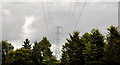
Pylon and power lines near Dromore (2)
A continuation, eastwards, of Image The lines are crossing the dual carriageway. The pylon is on the eastern side of the road. The grid continues towards here Image
Image: © Albert Bridge
Taken: 6 Aug 2011
0.02 miles
2
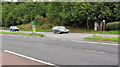
Central reservation gap near Dromore (3)
A gap in the central reservation opposite the northern end of the Halfway Road Image The northbound carriageway is in the foreground.
Image: © Albert Bridge
Taken: 6 Aug 2011
0.19 miles
3
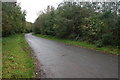
The Halfway Road near Domore (1)
See Image The present road and the line of the old are almost the same in part of this square. This is the Halfway Road, looking towards Banbridge, from the corner of Lisnaward Hill, close to where it joins the present dual carriageway. It continued to the section of old road shown in the link. The section behind me is a cul-de-sac.
Image: © Albert Bridge
Taken: 28 Oct 2006
0.21 miles
4
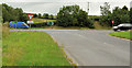
The Halfway Road near Dromore (3)
The northern end of the Halfway Road Image (formerly part of the main road) approaching the present dual carriageway.
Image: © Albert Bridge
Taken: 6 Aug 2011
0.22 miles
5
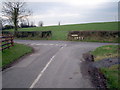
Junction of Barrack Hill and Mount Ida Roads, Dromore
Image: © P Flannagan
Taken: 15 Feb 2008
0.22 miles
6
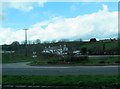
Houses on Halfway Road
The image was taken from the A1 at a point roughly equidistant between Dromore and Banbridge.
Image: © Eric Jones
Taken: 2 Apr 2011
0.22 miles
7
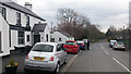
The Halfway Road near Banbridge
Part of the old Belfast-Dublin Road, the popular Halfway House pub/restaurant is located here.
Image: © Rossographer
Taken: 9 Apr 2017
0.23 miles
8
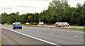
Central reservation gap near Dromore (2)
A gap, north of Image, now closed by cones. It was originally intended for use by agricultural vehicles crossing and had no bay or deceleration lane for right turns. The northbound carriageway is in the foreground.
Image: © Albert Bridge
Taken: 6 Aug 2011
0.24 miles