IMAGES TAKEN NEAR TO
Dromore Road, BANBRIDGE, BT32 4EQ
Introduction
This page details the photographs taken nearby to Dromore Road, BT32 4EQ by members of the Geograph project.
The Geograph project started in 2005 with the aim of publishing, organising and preserving representative images for every square kilometre of Great Britain, Ireland and the Isle of Man.

There are currently over 7.5m images from over14,400 individuals and you can help contribute to the project by visiting https://www.geograph.org.uk
Image Map
Images are licensed for reuse under creativecommons.org/licenses/by-sa/2.0
Notes
- Clicking on the map will re-center to the selected point.
- The higher the marker number, the further away the image location is from the centre of the postcode.
Image Listing (8 Images Found)
Images are licensed for reuse under creativecommons.org/licenses/by-sa/2.0
Image
Details
Distance
1
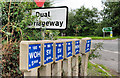
60mph speed limit signs near Banbridge
The Banbridge bypass now has five flyovers but still retains two gaps in the central reservation. It remains subject to a speed limit of 60mph. This is the start of the zone at Tullyraine. The northbound carriageway is in the foreground.
Image: © Albert Bridge
Taken: 7 Aug 2010
0.09 miles
2
Roadside post near Banbridge (1)
Roads Service post, beside the northbound carriageway at Tullyraine, on the Dromore side of Banbridge.
Image: © Albert Bridge
Taken: 7 Aug 2010
0.11 miles
3
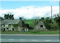
Derelict farmhouse besides the A1
This is situated just south of the junction with Waringsford Road. It also faces across the road the large Tullyraine Aggregate Quarries.
http://tullyrainequarries.co.uk/
Image: © Eric Jones
Taken: 2 Apr 2011
0.12 miles
4
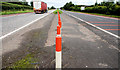
Central reservation gap near Banbridge (3)
Gap, on the Banbridge side of the Graceystown Road, at Tullyraine. Now closed using plastic bollards. There is a field entrance nearby but I cannot remember any other entrances here. The red lines (right) precede the 60mph zone for the Banbridge bypass.
Image: © Albert Bridge
Taken: 7 Aug 2010
0.14 miles
6

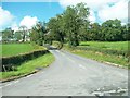
Farm access lane off the A1(Dromore Road)
Image: © Eric Jones
Taken: 26 Aug 2011
0.23 miles
7
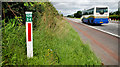
Fire hydrant posts near Banbridge
“WOH” (wash out hydrant) and “SV” (stop valve) posts at the end of the Graceystown Road.
Image: © Albert Bridge
Taken: 7 Aug 2010
0.24 miles
8
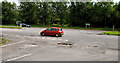
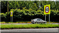
Central reservation gap near Banbridge (2)
Gap opposite the Graceystown Road (foreground). The red car is on the northbound carriageway.
Image: © Albert Bridge
Taken: 7 Aug 2010
0.24 miles