IMAGES TAKEN NEAR TO
Whitehill Road, CASTLEWELLAN, BT31 9TJ
Introduction
This page details the photographs taken nearby to Whitehill Road, BT31 9TJ by members of the Geograph project.
The Geograph project started in 2005 with the aim of publishing, organising and preserving representative images for every square kilometre of Great Britain, Ireland and the Isle of Man.

There are currently over 7.5m images from over14,400 individuals and you can help contribute to the project by visiting https://www.geograph.org.uk
Image Map
Images are licensed for reuse under creativecommons.org/licenses/by-sa/2.0
Notes
- Clicking on the map will re-center to the selected point.
- The higher the marker number, the further away the image location is from the centre of the postcode.
Image Listing (13 Images Found)
Images are licensed for reuse under creativecommons.org/licenses/by-sa/2.0
Image
Details
Distance
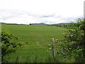
1
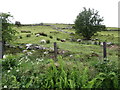
Grazing land on Benraw Mountain
The image was taken from Whitehill Road.
Image: © Eric Jones
Taken: 7 Jun 2017
0.03 miles
3
View ENE across the upper Leitrim Valley
The hill in the background is Slievegarran. The image was taken from the Whitehill Road.
Image: © Eric Jones
Taken: 7 Jun 2017
0.10 miles
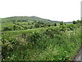
6
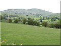
Drumlin landscape north of Whitehill Road
The hills beyond are members of the Slieve Croob range and include, with the aerials on the summit, Slieve Croob itself.
Image: © Eric Jones
Taken: 7 Jun 2017
0.18 miles
7
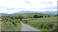
Benraw Mountain from the Legananny Road
Benraw Mountain is the hill capped by a wind turbine. Much of the 'Mountain' is in improved grassland. The mountain separates the Whitehill and Benraw roads. The High Mournes form the background.
Image: © Eric Jones
Taken: 7 Jun 2017
0.19 miles
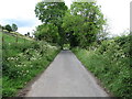
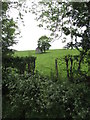
8

Field gates on the Whitehill Road
These give access to fields which dip down into the Leitrim Valley. The hill in the background is Slievegarran.
Image: © Eric Jones
Taken: 7 Jun 2017
0.19 miles
9
Drumlin on the north side of Whitehill Road
The summit of Slieve Croob can be seen in the background -- easily identifiable from its forest of telecommunications masts.
Image: © Eric Jones
Taken: 7 Jun 2017
0.20 miles
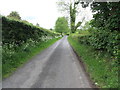
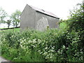
10
Field barn on the side of Benraw Mountain
The image was taken from the Whitehill Road.
Image: © Eric Jones
Taken: 7 Jun 2017
0.22 miles