IMAGES TAKEN NEAR TO
Drumlee Road, CASTLEWELLAN, BT31 9RS
Introduction
This page details the photographs taken nearby to Drumlee Road, BT31 9RS by members of the Geograph project.
The Geograph project started in 2005 with the aim of publishing, organising and preserving representative images for every square kilometre of Great Britain, Ireland and the Isle of Man.

There are currently over 7.5m images from over14,400 individuals and you can help contribute to the project by visiting https://www.geograph.org.uk
Image Map
Images are licensed for reuse under creativecommons.org/licenses/by-sa/2.0
Notes
- Clicking on the map will re-center to the selected point.
- The higher the marker number, the further away the image location is from the centre of the postcode.
Image Listing (10 Images Found)
Images are licensed for reuse under creativecommons.org/licenses/by-sa/2.0
Image
Details
Distance
1
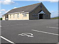
The Drumlee Road Presbyterian Hall
The OSNI 1:2500 map shows this hall and the nearby chapel in square J2636. The grid used on the Geograph Map in this district is based on the 1:50,000 and is not correctly aligned.
Image: © Eric Jones
Taken: 26 Mar 2011
0.02 miles
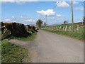
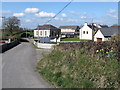
2
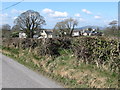
Nearing the hamlet of Drumlee, north-west of Kilcoo
Image: © Eric Jones
Taken: 26 Mar 2011
0.04 miles
3
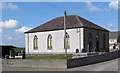
Drumlee Presbyterian Church from the south
Image: © Eric Jones
Taken: 26 Mar 2011
0.04 miles
5
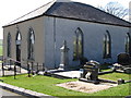
The Drumlee Presbyterian Church
The Drumlee Presbyterian Church was built in 1827 at the then substantial cost of £189. It has an attached graveyard.
Image: © Eric Jones
Taken: 26 Mar 2011
0.07 miles
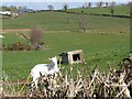
6
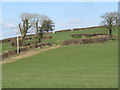
A rath above the Drumlee Road
This is a very good example of a rath i.e. a ringfort. Such structures date back to the Iron Age and were in use until the early Middle Ages. It is not often one sees a rath which is not chocked with overgrown vegetation. Traditionally farmers have been wary of clearing thickets from within raths as these ringforts were considered to be fairy rings.
Image: © Eric Jones
Taken: 26 Mar 2011
0.16 miles