IMAGES TAKEN NEAR TO
Church Place, CASTLEWELLAN, BT31 9FZ
Introduction
This page details the photographs taken nearby to Church Place, BT31 9FZ by members of the Geograph project.
The Geograph project started in 2005 with the aim of publishing, organising and preserving representative images for every square kilometre of Great Britain, Ireland and the Isle of Man.

There are currently over 7.5m images from over14,400 individuals and you can help contribute to the project by visiting https://www.geograph.org.uk
Image Map
Images are licensed for reuse under creativecommons.org/licenses/by-sa/2.0
Notes
- Clicking on the map will re-center to the selected point.
- The higher the marker number, the further away the image location is from the centre of the postcode.
Image Listing (309 Images Found)
Images are licensed for reuse under creativecommons.org/licenses/by-sa/2.0
Image
Details
Distance
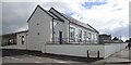
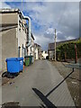
1
The Church Street extension to Castlewellan's Community Centre
Image: © Eric Jones
Taken: 28 Sep 2022
0.07 miles
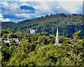
2

The Co Down town of Castlewellan from the summit of Slieve Donard
The range of hills behind the town is that of Slieve Croob.
Image: © Eric Jones
Taken: 11 Jun 2014
0.08 miles
3
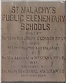
Tablet on the former St Malachy's Primary School now Castlewellan's Community Centre
Image: © Eric Jones
Taken: 28 Sep 2022
0.08 miles
5
Castlewellan Community Centre, Circular Road, Castlewellan
This building was originally the St Malachy's (Catholic) Primary School. After a new parochial school was built adjacent to the parish church, the building was converted into a much need community centre. For some years part of it was occupied by the nascent Bunscoil Bheanna Boirche, Castlewellan's Irish medium school. Following a major growth in pupil numbers this school moved to a purpose-built campus further along the street.
Image: © Eric Jones
Taken: 28 Sep 2022
0.09 miles
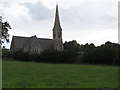
7
The steeple of St Paul's CoI viewed from Bunkers Hill
In the background is Castlewellan Castle, the former home of the Annesleys surrounded by its parkland and forests. St Paul's was the place of worship of the Anglican Annesleys and most of their senior retainers.
Image: © Eric Jones
Taken: 28 Sep 2022
0.10 miles
8
The rear of commercial buildings in the Upper Square, Castlewellan
The image was taken in Mary Street.
Image: © Eric Jones
Taken: 28 Sep 2022
0.10 miles
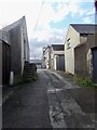
9

Mary Street, Castlewellan
These are the backs of commercial premises in the Upper Square.
Image: © Eric Jones
Taken: 28 Sep 2022
0.10 miles
10
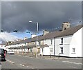
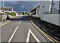
Terraced housing in Circular Road, Castlewellan
Image: © Eric Jones
Taken: 28 Sep 2022
0.10 miles