IMAGES TAKEN NEAR TO
Drumulcaw Road, DOWNPATRICK, BT30 8SB
Introduction
This page details the photographs taken nearby to Drumulcaw Road, BT30 8SB by members of the Geograph project.
The Geograph project started in 2005 with the aim of publishing, organising and preserving representative images for every square kilometre of Great Britain, Ireland and the Isle of Man.

There are currently over 7.5m images from over14,400 individuals and you can help contribute to the project by visiting https://www.geograph.org.uk
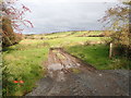
Image Map
Images are licensed for reuse under creativecommons.org/licenses/by-sa/2.0
Notes
- Clicking on the map will re-center to the selected point.
- The higher the marker number, the further away the image location is from the centre of the postcode.
Image Listing (15 Images Found)
Images are licensed for reuse under creativecommons.org/licenses/by-sa/2.0
Image
Details
Distance
2

Waterlogged potato field on the Drumulcaw Road
Heavy rain this Autumn has made potato harvesting in Ireland particularly difficult. Potato prices are likely to rise in the run-up to Christmas.
Image: © Eric Jones
Taken: 15 Nov 2019
0.05 miles
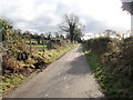
3
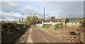
Approaching houses on the North side of Drumulcaw Road
Image: © Eric Jones
Taken: 15 Nov 2019
0.06 miles
4

Waterlogged Potato Field below Drumulcaw Road
Heavy rain this Autumn has made potato harvesting in Ireland particularly difficult. Potato prices are likely to rise in the run-up to Christmas.
Image: © Eric Jones
Taken: 15 Nov 2019
0.09 miles
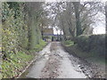
5
Tree lined section of Drumulcaw Road in Late Autumn
Image: © Eric Jones
Taken: 15 Nov 2019
0.12 miles
6
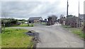
The Shanbally Road junction on the Drumulcaw Road
Drumulcaw Road continues southwards as a track providing access to a number of farms and houses.
Image: © Eric Jones
Taken: 15 Nov 2019
0.14 miles
7
Field track on land between Shanbally Road and Drumanaghan Road
This area is part of the extensive drumlin belt between the Slieve Croob Range and the Mournes.
Image: © Eric Jones
Taken: 15 Nov 2019
0.17 miles
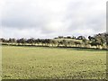
8

Drumlin landscape East of the Ballynahinch Road
Much of the land is used as pasturage
Image: © Eric Jones
Taken: 15 Nov 2019
0.18 miles
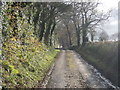
9
View South along Drumulcaw Road
This local access road is part of the link between Ballynahinch Road and Demesne Road.
Image: © Eric Jones
Taken: 15 Nov 2019
0.20 miles
10
Drumlin summit rath above Drumulcaw Road, Srib TD
The rath is known locally as Cusack's Fort. The image was taken from the Drumulcaw Road.
https://apps.communities-ni.gov.uk/NISMR-PUBLIC/docs/DOW/DOW_036/DOW_036_012/Public/SM7-DOW-036-012.pdf
Image: © Eric Jones
Taken: 15 Nov 2019
0.20 miles