IMAGES TAKEN NEAR TO
Ballydugan Road, DOWNPATRICK, BT30 6TE
Introduction
This page details the photographs taken nearby to Ballydugan Road, BT30 6TE by members of the Geograph project.
The Geograph project started in 2005 with the aim of publishing, organising and preserving representative images for every square kilometre of Great Britain, Ireland and the Isle of Man.

There are currently over 7.5m images from over14,400 individuals and you can help contribute to the project by visiting https://www.geograph.org.uk
Image Map
Images are licensed for reuse under creativecommons.org/licenses/by-sa/2.0
Notes
- Clicking on the map will re-center to the selected point.
- The higher the marker number, the further away the image location is from the centre of the postcode.
Image Listing (30 Images Found)
Images are licensed for reuse under creativecommons.org/licenses/by-sa/2.0
Image
Details
Distance
1
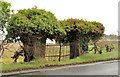
Old gateposts, Downpatrick
A disused gate, supported by two ivy-clad gateposts, on the northern side of the Ballydugan Road (to Clough).
Image: © Albert Bridge
Taken: 22 Feb 2012
0.05 miles
2

Drumlin hollow wetland on the Western outskirts of Downpatrick
The waterlogged nature of the hollow contrasts with the well drained soils of the drumlin. The drumlin forms an 'island' of cropland on the flood plain of the Quoile River.
Image: © Eric Jones
Taken: 1 Oct 2020
0.07 miles
3
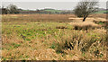
Marsh and drumlins, Downpatrick
A scene typical of the topography of this part of Co Down, drumlins Image forming a background to the low marshy land between the Ballydugan Road and the Quoile Image
Image: © Albert Bridge
Taken: 22 Feb 2012
0.08 miles
4
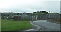
Ballydugan Industrial Estate, Downpatrick
This small industrial estate is located off the Ballydugan Road (A25).
Image: © Eric Jones
Taken: 24 Oct 2009
0.09 miles
5

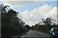
Houses in the Demesne of Down, Downpatrick
This southern extension of modern housing runs parallel with the A25 Ballydugan Road. The white tower on the summit of the drumlin is that of St Colmcille RC Church, Ballymote
Image
Image: © Eric Jones
Taken: 20 Aug 2009
0.09 miles

8

Wasteland on the south-western edge of Downpatrick
Google Maps show foundation trenches dug on the site'
app
Image: © Eric Jones
Taken: 1 Oct 2020
0.18 miles
9

S.Colmcille Church, Downpatrick
A refreshing modern style church.
Image: © Peter Benton
Taken: 5 Feb 2006
0.18 miles
10

Tilled drumlin land West of the A25
This drumlin forms an 'island' of cultivation in area of wetland and forest.
Image: © Eric Jones
Taken: 1 Oct 2020
0.19 miles