IMAGES TAKEN NEAR TO
Strangford Road, DOWNPATRICK, BT30 6SR
Introduction
This page details the photographs taken nearby to Strangford Road, BT30 6SR by members of the Geograph project.
The Geograph project started in 2005 with the aim of publishing, organising and preserving representative images for every square kilometre of Great Britain, Ireland and the Isle of Man.

There are currently over 7.5m images from over14,400 individuals and you can help contribute to the project by visiting https://www.geograph.org.uk
Image Map
Images are licensed for reuse under creativecommons.org/licenses/by-sa/2.0
Notes
- Clicking on the map will re-center to the selected point.
- The higher the marker number, the further away the image location is from the centre of the postcode.
Image Listing (11 Images Found)
Images are licensed for reuse under creativecommons.org/licenses/by-sa/2.0
Image
Details
Distance
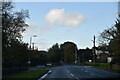
2
Houses above the Strangford Road in the suburbs of Downpatrick
Image: © Eric Jones
Taken: 25 Jun 2013
0.10 miles
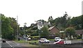
3
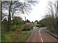
Entering the Downpatrick 30mph zone on the A22
Image: © Eric Jones
Taken: 17 Apr 2017
0.19 miles
4
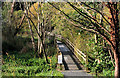
Footbridge, Downpatrick (2)
A footbridge, on the Jane’s Shore path serving the same purpose as this one Image (further to the south west). The view is from the Old Belfast Road.
Image: © Albert Bridge
Taken: 6 Oct 2010
0.20 miles
5
Jane's Shore, Downpatrick (3)
Jane’s Shore Image, at one of two entrances from the Old Belfast Road.
Image: © Albert Bridge
Taken: 24 Sep 2008
0.20 miles
6

Autumn leaves, Downpatrick (2)
Autumn leaves by the Jane’s Shore path.
Image: © Albert Bridge
Taken: 3 Nov 2010
0.21 miles
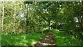
7

The Old Belfast Road, Downpatrick (1)
A wooded stretch of the Old Belfast Road, south of the Quoile Bridge Image The Quoile Image is behind the trees on the right. 18th century Downpatrick was an important administrative centre and little effort is needed to imagine the mail coach, or the prison wagon heading for the Assizes, passing here – don’t think there were any white lines or cats’ eyes then though.
Image: © Albert Bridge
Taken: 24 Sep 2008
0.22 miles
8
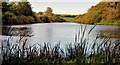
The Quoile, Downpatrick (2)
There is a path, off the Old Belfast Road, alongside the Quoile. It leads to the Jane’s Shore path and gives this view, upstream, along the slow and meandering Quoile River. The banks are wooded and showing signs of autumn colour.
Image: © Albert Bridge
Taken: 6 Oct 2010
0.23 miles
9
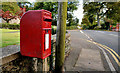
Letter box, Downpatrick
Post-mounted EIIR box, at Quoile Park, on the Old Belfast Road.
Image: © Albert Bridge
Taken: 6 Oct 2010
0.23 miles
10

The Quoile, Downpatrick
The wooded bank on the eastern side of the Quoile close to Image
Image: © Albert Bridge
Taken: 24 Sep 2008
0.24 miles