IMAGES TAKEN NEAR TO
Rathdune Grove, DOWNPATRICK, BT30 6AT
Introduction
This page details the photographs taken nearby to Rathdune Grove, BT30 6AT by members of the Geograph project.
The Geograph project started in 2005 with the aim of publishing, organising and preserving representative images for every square kilometre of Great Britain, Ireland and the Isle of Man.

There are currently over 7.5m images from over14,400 individuals and you can help contribute to the project by visiting https://www.geograph.org.uk
Image Map
Images are licensed for reuse under creativecommons.org/licenses/by-sa/2.0
Notes
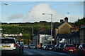
- Clicking on the map will re-center to the selected point.
- The higher the marker number, the further away the image location is from the centre of the postcode.
Image Listing (76 Images Found)
Images are licensed for reuse under creativecommons.org/licenses/by-sa/2.0
Image
Details
Distance
1
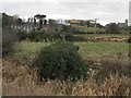
Reclaimed marshland below the Down High School
Downpatrick Cathedral stands to the right.
Image: © Eric Jones
Taken: 4 Mar 2014
0.03 miles
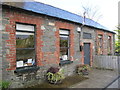
2
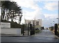
The Trinity Housing Association's Cedar Court in Bridge Street, Downpatrick
This £4 million sheltered accommodation for the elderly was opened in June 2013.
"The scheme has 24 apartments in total, 12 for frail older people and 12 for dementia. Each has a living room, kitchen, one or two bedrooms, and bathroom" (Downnews).
http://www.downnews.co.uk/3-8-million-cedar-court-development-opens-in-downpatrick-for-elderly/
http://www.trinityha.org/pages/about-us/
Image: © Eric Jones
Taken: 4 Mar 2014
0.05 miles
3
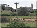
Powerlines crossing the N52 Quoile Marshes
These follow the low ground between Down Cathedral on the right and Down High School on the left.
Image: © Eric Jones
Taken: 4 Mar 2014
0.06 miles
4
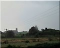
View south across the Quoile Marshes
In the background right is the Mound of Down surmounted by a medieval motte and on the right is Down Cathedral.
Image: © Eric Jones
Taken: 25 Nov 2015
0.08 miles
7
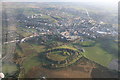
The Mound of Down
The Mound of Down is an Iron Age hill fort which had a Norman motte built within the ring earthwork. An aerial photo from helicopter.
Image: © John Martin
Taken: 30 Nov 2008
0.09 miles
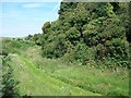
8

Natural meadow on the earthworks at the Mound of Down
Image: © Eric Jones
Taken: 4 Jul 2011
0.09 miles
9
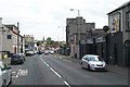
View south along Church Street, Downpatrick
Image: © Eric Jones
Taken: 25 Jun 2013
0.10 miles
10
Union Chapel/ Prayer Meeting House in Bridge Street
This evangelical meeting house was erected in 1861. It is also known as Pilson Hall after the radical diarist Aynsworth Pilson, who was the proprietor of the Downpatrick Recorder. The building is still in use.
Image: © Eric Jones
Taken: 4 Mar 2014
0.11 miles